 The results from the recently released UC Davis Campus Travel survey are encouraging. The results from the 2013-14 survey show that around 47 percent of the people traveling to campus on an average weekday commute by bike, whereas only 24 percent drive alone.
That represents nearly a 25 percent increase from 2007 when 38 percent of commuters used their bicycles. The 2013-14 survey calculated that approximately four people are riding in each vehicle coming to campus on an average weekday, significantly more than the ridership per car at other campuses, and only 24 percent of commuters drive alone.
The average UC Davis commuter generates 7.6 lbs. of CO2 equivalent emissions each day, down from 12 lbs. of CO2 per person in 2007.
During a time when communities are attempting to cut back on their carbon emissions and get people out of their vehicles, these are encouraging findings.
Housing is a key condition that determines how people travel to campus. Natalie Popovich, who is the graduate student who administered the 2013-14 survey, wrote in the report, “The results suggest that mode splits vary substantially by neighborhood. Bicycling to campus is especially prevalent among individuals living in Central and Downtown Davis. Those living in Downtown Davis are much more likely to walk to campus than individuals living elsewhere. Driving to campus is more common from the neighborhoods of East and South Davis, and taking the bus to campus is more common from North and South Davis.”

The survey results show that commuters are less likely to bicycle between south Davis and the campus as opposed to other parts of town. This suggests that I-80 and the train tracks represent a perceived barrier even though there are tunnels and access points.
[callout bg=”#000000″ color=”#ffffff” font=”0″ fontsize=”14″ bt_content=”Donate Now” bt_pos=”right” bt_style=”undefined” bt_color=”red” bt_link=”https://secure.yourpatriot.com/ou/dpd/friends_of_the_vanguard/donate.aspx” bt_target=”_blank” bt_font=”0″]If you haven’t already signed up to become a subscriber – Please donate today by clicking on the link. You can also make a one-time payment starting at $120 to become a subscriber. You can do so either by credit card at the previous link or by mailing a check to Davis Vanguard, PO Box 4715, Davis, CA 95617[/callout]
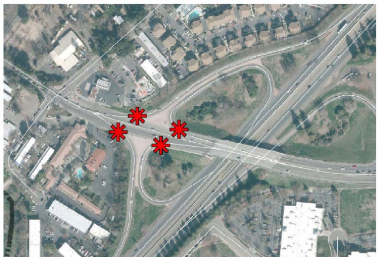
 Richards Blvd Interchange
A few weeks ago we reported on the city’s application that would allocate $160,000 in Roadway Impact Fee funds to cover the estimated costs to prepare the Project Study Report and authorize initial work on Richards Boulevard interchange improvements.
“Approximately 400 bicyclists and 200 pedestrians cross the Richards Boulevard interchange every day. North of I-80, between the freeway and the Richards underpass, the Richards Boulevard interchange is a four-quadrant cloverleaf,” staff writes. “The interchange configuration, in which all vehicle movements are uncontrolled, results in high vehicle speeds onto and off from the freeway ramps. These high-speed movements create a safety concern for all modes on Richards Boulevard, particularly bicyclists and pedestrians.”
This becomes fodder for a Bob Dunning column over the weekend. Mr. Dunning notes, “The problem, of course, starts with the narrow two-lane tunnel that chokes traffic coming into and going out from the lovely and charming city of Davis. It’s a historic tunnel, you see, and when ‘fixing’ it was put on the ballot a number of years ago, the argument was that expanding it to four lanes would be growth-inducing.”
Regardless of the Richards Underpass, the interchange is problematic, feeding large numbers of vehicles onto an already congested roadway without clear rules of engagement. Rather than having a lane to absorb the traffic, particularly the westbound exiting traffic onto northbound Richards, which merges directly into the main traffic lane.
Given bicyclists, pedestrians, and the interflow of traffic, this is problematic.
In the meantime, the city is looking at a Hotel Conference Center across the street, and Nishi is being planned with potential access on Olive to Richards Blvd.
City voters rejected a plan around 15 years ago to widen the Richards underpass to four traffic lanes. While widening the underpass was perhaps seen as growth inducing, the larger problem would have been that congestion would have been pushed into the downtown as the narrow streets would not be able to handle the high volume of traffic coming through the underpass.
Anecdotally, during the morning commute when backups at the underpass are at their worst, the highest volume of traffic turns left at 1st Street and heads toward campus. This suggests that potentially rerouting traffic flows onto campus might be a better solution that widening the roadway.
Encouraging alternative transportation such as the train, where people could then walk or bike to campus, is another way to go. That dovetails into the discussion from the previous section on mode share in travel to campus, while studies suggest less than a quarter drive alone, clearly the university should be finding ways to further reduce those numbers, especially as Nishi and other projects come on line.
Regardless, fixing the interchange is needed and long overdue. However, even if Davis gets the funding, don’t expect changes very quickly. It will take about five years for the planning to occur and construction would not begin until 2022.
As we know, the 5th Street project took years to plan and get approved as well. That was a dangerous situation. Planning takes time, but perhaps the city can look at ways to expedite things.
Comparing Employee Salaries
The Center for Investigative Reporting has launched Payday California “to provide additional information and more context for public employee pay.”
It is based on data collected and published by the California State Controller’s Office, which “has collected and published compensation data on as many as 700,000 city and county employees annually from 2009 through 2012.”
“Payday California also includes additional employee compensation records from the 10 most populous counties and 10 most populous cities in California. CIR requested data for calendar years 2008 through 2012; the state controller’s data currently includes 2009 through 2012.
“The data we obtained from cities and counties differs from the state’s in two additional ways: 1) We include employees’ names; the State Controller’s Office does not. 2) We asked for employees’ gross pay prior to deductions. The State Controller’s Office requests employees’ total wages subject to Medicare taxes, which tend to be lower than gross wages.”
Naturally, we ran the city of Davis’ numbers. Unfortunately, the most recently available year is for 2012. We suggest you hit the link to go to the site since it is interactive: http://payday.cironline.org/city/davis/.

—David M. Greenwald reporting


the salary chart is interesting as it seems like davis has a bit of a skewed shape pushing more employees into the $100K range. but it might be more interesting if we were able to compare city to city rather than the general distribution curves.
the first two articles are interesting in that i think we need to really look at how to change traffic patterns as we plan nishi and further development off of richards. can we encourage traffic to go other ways to get to ucdavis? what if we made first street, one way headed east only?
I’m surprised no mention of the Gateway project. I was at first skeptical. After listening to the plans, I was convinced and added a couple of ideas to the process (that hopefully made their way into the process — never sure what happens to “public input”).
Diverting University traffic left at Olive, through Nishi, avoids the mass of cars through the tunnel when it is in crush mode, and off 1st street.
Pedestrian circulation around Richards/Olive is rather brilliantly handled by the bridge, which, due to the road going down, has only a gentle rise above the roadway elevation.
My further suggestions were connecting directly from the bridge south to the Putah bike path, via an existing utility easement adjacent to the tracks, to avoid having to have bike/ped go back to Olive and mix with car traffic.
Other is on downtown side of Olive via new north side ped/bike tunnel, to continue around and connect to 1st & F and continue a two-way bike path around the corner, with just the half block F to 1st, around the corner itself, converted to S to W one-way only for auto. This would allow a safe and direct bike route to/from downtown from Olive without having to cross either 1st & F or Olive & Richards, a savings of about 4 minutes average with the distance plus long lights, and bikes avoid car interactions at both. Much as I loath one-way streets, limiting this from 1st & F to the first driveway after the corner would allow two-way to all businesses such as the motel, the ability to circle back behind the Village Bakery building, while cars would turn into downtown off 1st onto F only rather than down to G.
Alan… concept of diverting UCD traffic left onto Olive may look good on paper, but would screw up the intersection big time with long cycle lengths. Better to close Old Davis Road, so UCD traffic would have to use something other than the Richards/First corridor.
If you want to improve traffic flow, increase the number of options for travel routes, not reduce them. Best option would be to have access through both Olive Drive and Old Davis Road, not just one or the other.
You apparently do not understand signal timing. Left turn movements, plus clearance phase, take a lot of real capacity out of the intersection. The predominant movements are, and will be the ones destined for the Core, and north. If UCD traffic was eliminated, capacity would be improved. If UCD traffic could either turn left or continue straight, the intersection of Olive/Richards would fail much more than currently. Through movements, given the predominant movements, impact the intersection much less than the left turn movements. It is what it is.
Thanks for the feedback, I really appreciate it. I guess then that the same could be said of anyone involved with planning the City’s traffic flow since, well, at least the mid 70’s when I started driving.
Really? Amazing! Who’d a thunk it?
Traffic congestion at Olive and Richards is primarily an issue during commute times. Why stop access at all times if the problem is during a narrow window? I understand that there’s a new high tech item called a road sign that can be hung next to the traffic light stating ‘no left turn between the hours of …’ (wow, what a novel concept). The same at the ‘other end of the pipe’ at Old Davis Road if it is needed there as well.
What is truly amazing to me (but then, I apparently don’t understand this esoteric topic) is that we are contemplating developing Nishi without having access at Richards. Oh well, what can you expect from a City full of people with more education than sense.
Mark… sorry you apparently took offense at my “short” answer. In retrospect, I can see where I came off as “dismissive”. Not my intent, ‘my bad’.
You are absolutely correct in saying that multiple pathways are almost always better for travel dispersal and generally reduce the problems of ‘congestion’. that’s one of the problems with Cannery, as approved, where access to L and one or two connections to Pole Line were dismissed as “growth inducing”.
Your concept of “time of day” restrictions CAN work, but at the cost of needing more resources for controlling such access, including ‘enforcement’. Those are on-going costs, and may be significant. Ever notice how the ramps near Richards are signed on Picnic Day? That’s just one day of effort. Such restrictions also have problems if the roadway users are not “frequent flyers”.
Unless we are truly prepared to reconfigure W Olive Drive, possibly affecting the existing abutting properties in a significant way, my opinion is that W Olive Drive should ONLY serve the Nishi site for ped/bike and emergency vehicle purposes. (or, we could use Nishi as a “buffer”, and not develop it). Nishi needs at least two viable motor vehicle accesses to UCD. (and at least as many, or more bike/ped)
The simplistic answer to just divert UCD bound traffic from Richards, via Nishi, to UCD, just fails the “who thunk” test. My point.
The flawed design of the Richards corridor has more to do with ‘planners’ (with no background in transportation), commissioners, the electeds and the electorate than with transportation engineers. It was “sold” to the voters that widening the Richards Overhead (tunnel) would result in the development in south Davis beyond the few hundred houses that existed ~ 1972. The “anti” folks said that NOT WIDENING the crossing under the RR would prevent the “sprawl” south of I-80… This was ~ 1972-73. Yeah, that was successful, big time. Voters rejected the widening. It was again rejected by the omniscient electorate in the ’90’s.
Hope that helps.
I appreciate the logical look at traffic flow, and agree the so-called planners were either inexperienced or overridden in traffic design for some of the most critical intersections.
Mr West has the basic concept down, that more avenues are better, but the fallacy that slow traffic improvements mean slow growth is demonstrated again and again in Davis and Sacramento.
In IT talk, this is known as a “single point of failure”. People utilize options when they are given, and people trying to keep growth down by creating slower traffic in and out of town, only hurts your citizens, employees and merchants. I thought those people were important, and why Target has huge parking lots and locates itself on the edge of a freeway.
Sacramento keeps widening the few routes across their rivers, and ANY traffic problems blocks the whole avenue. More people get inconvenienced when anything goes wrong. What kind of planning is that?
UC Davis has the same problem, with decades old avenues in and out of campus, which they then use to slow traffic. Davis has modified enough at the Tunnel, including a frog tunnel. They build more apartments on Olive Drive, which now must be a pleasure to live, since the rails on one side and freeway on the other must be great for the ambiance of living near an In-and-Out.Even the Java Place on the corner of Olive generates its own surges in congestion. Planning? I believe it is..
Caltrans cannot even get the freeways right, they are too crowded.
Maybe. I don’t think anyone could definitely answer the question until it is modeled, and that only after a road design is completed to enter into the model. ODR is also a good idea. The point is to take 80 to University traffic out of downtown, and the need for increased traffic capacity on Richards to downtown is therefore greatly diminished.
OK, modelling “good”. If your proposal is modelled (and it should be, if only to show why it won’t work), I offer you the following wager: if you win, I will acknowledge that you appear to be right, AND will pay for you and 9 of your friends to a dinner @ Dos Coyotes; if I win, you acknowledge I appear to be right. The reason I give odds that generous is that I have studied traffic patterns for years, and have rarely been surprised when my gut reaction did not substantially agree with models and/or actual results (significantly wrong less than 10% or the time, hence the terms of the wager).
Dos Coyotes?
Is that your only offer?
[This is a reply to hpierce, but for some reason there’s no Reply link below his post on my browser.)
My recollection of the Measure E campaign — and my vote for against widening — had nothing to do with development of south Davis, and everything to do with congestion in the core. I think by then I’d already written off south Davis as Vacaville lite.
With regard to the widening discussion in the early ’70s, I just don’t remember, and I’m pretty sure I wasn’t really paying attention then anyway.
HP,
OK, restaurant choices aside, I don’t disagree with you, nor do I agree. I was perplexed about running Olive through until I talked to the developer of Nishi and the idea of running the cars that take 1st onto Olive instead came up, and it has merit. Having said that, that is one challenging intersection. I was intrigued with the idea, but it certainly has to be modeled. You may be right. On the other hand, the Richards to 1st corridor is pretty dysfunctional as it is, especially at commute time. I know what you mean about gut feelings and models, often with some experience you can get a good sense. This one is so complex, I am not willing to call it at this point.
Alan – Since I am very much a “visual” learner, I think I need a diagram of what you are describing. I think I get part of it but look forward to talking in-person so I can see it. Thanks
You know I’m always up for sitting down with a map and a bunch of colored pens.
Distance and travel time place south Davis at a disadvantage for commuting to campus by cycling. I make this assumption using Shields Library as the campus destination point and high density housing in the six neighborhoods as points of trip origin.
I agree, I live in Northeast Davis and it’s a distance and travel time issue out here, not a problem crossing railroad tracks.
If I-80 and the train tracks are seen as a barrier then that means we have not done a good job on providing information (and signage) to encourage the use of the I-80 and UPRR under crossings that come into town behind Whole Foods. In fact, I am pretty sure we have done a poor job at both (information and signage).
Just FYI, from the intersection of Cowell and Mace in south Davis it is 4.1 miles to Shields using the Putah Creek bike path and these under crossings. By way of comparison, the trip from the intersection of Arlington and Lake is 3.1 miles by bike (heading down Lake to the Russell bike path and across 113 on the bike bridge by West Village). A trip from the Covell/Pole Line intersection is 2.5 miles by bike (taking Pole Line to some good side streets and eventually to L and 3rd).
Talk to any casual cyclist (not a vehicular one) and s/he will tell you that of these three trips the most scenic and enjoyable (and, since mostly Class I–bike path, least stressful) is the Putah Creek path.
I-80 and the rail line should NOT be barriers from South Davis.
Robb – Since I am very much a “visual” learner, I think I need a diagram of what you are describing. I think I get part of it but look forward to your posting a bike path image here so I (and everyone else) can see it. Thanks
P.S. Can we get Google Maps to photograph the Davis Bike Path network and add it as a layer in Google Maps?
Good one Matt!
Here is the Google Maps image of that bicycle route.

.
Davis bike paths have been mapped and available on the free download version of Google Earth for years. It is very easy to use the map ruler and it’s path function to trace out bike paths, bike lanes and streets. You may measure the route distances with GPS accuracy in meters, feet, miles, etc. Any route or path may be saved and screen shots are easy to do. You can even map and measure a round trip route from your house to Stevenson Bridge and beyond if you want to.
Dan, since our two bicycles have not been removed from their garage ceiling hooks in at least 5 years, I’m a true dunce when it comes to personal knowledge of bike routes. For my wife and I they are superb dog walking venues for our two cocker spaniels. My connection with bicycles is that it is very clear that the majority of Davis residents do connect with bicycles, and do contribute to the overall quality of life here in Davis by doing so. So I try to listen and learn when bicycle issues are discussed.
You can download a nice Davis bike path map here.
http://taps.ucdavis.edu/sites/taps.ucdavis.edu/files/attachments/bikemap.pdf
Dan, I wasn’t clear in what I was looking for in my P.S. I regularly use Google Maps in street view mode in order to get a feel of what the flora and fauna (mostly flora) are on either side of a particular road that I am going to travel in the near future. It gives me a visual imprint that is helpful when I actually arrive at that location in my car. I was looking for that same flora and fauna visual for the Davis bike paths. Since I have walked the Putah Creek portion of the route Robb described beginning at Mace, and then continued westward across Drummond, along side Montgomery Elementary School and then up into Playfields Park, under Poleline and then down to Safeway through Interland, I am familliar with the visual beauty Robb described. Having that beauty accessible on the web was what I was trying to ask for … a map, and then some.
Robb, thanks for the route!
Matt, I’m glad you keep up with the Davis bike world. I use the bike paths in north Davis for walking on a daily basis. I ride on them too but usually choose the streets for cycling. Bike path walkers and pets are much more safe when I’m running the ancient Motobecane on the streets. Google Earth is my favorite for finding bike routes. In the satellite view mode I can see the actual paths if not covered by trees. Connector streets are yellow, residential streets are white and every single foot of paved bike path is traced in light gray. Google Earth is automatically updated with the latest street view images as well.
One reason people don’t like to take the bike path under 80 & UPRR is the part on the map just east of i-80 where it is NOT a class 1 bike path. A friend was T-boned by a left-turning car in that short stretch and thankfully rolled over the car and landed on her feet, but she could have just as easily been killed. This accident never would have happened if the bike path went through, north of, or south of the Rust Property. The City needs to close that gap ASAP.
With the Rust property for sale now is a good time to put in the bike path (so we all don’t have to continue to take the long way around the “front” of 950 Chiles on our bikes to get under I80).
http://www.zillow.com/homedetails/950-W-Chiles-Rd-Davis-CA-95618/16540593_zpid/
Well, I do ride around town on a bike and I have more than once found myself in South Davis headed toward a downtown destination on west bound Cowell Blvd. Making a left turn heading south on Research Park Drive is so counter-intuitive to getting to the downtown core that I have never tried it. I have found myself going over the Richards I-80 overpass and only regretting it once I’m on my descent toward the dreaded intersection at Richards. I can see that the Research Park route is not significantly longer, but it feels blocks longer when you’re riding in the bike lane on Cowell.
One aspect of riding a bicycle or walking is that one tends to focus on the shortest distance between points A and B. So a route that takes you two or three blocks away from a straight line seems truly out of the way. The only caveat to this is if a route is extremely scenic or fun. Research Park Drive doesn’t have that allure until you leave it for the tunnel. I’m sure I personally need to check out this alternative, but I wonder how many people would benefit from extra signage to get them off Cowell Blvd at Research Park Drive. As far as a fun alternative route, if the city could ever think of a way to tie the bicycle path that runs north of Putah creek into Slayback Lane before the path heads north to Research Park Drive and create a direct shot from the path to the tunnel, it would become a legendary fun route that would need little to no encouragement.
North Davis is a long bike ride to campus but it is a fairly straight and fast moving route compared to the ride from south Davis.
I’m surprised no one has commented on the fact that the UC Davis Campus Travel survey results for bicycle and pedestrian mode shares are all overstated due to the fact that commuters from outside of Davis were excluded from the survey. Given the vast majority of UC Davis commuters from outside of Davis travel by car (and to a lesser extent, by train), the mode shares for bike and ped are actually lower.
-Michael Bisch
Excellent point.
How about a giant dutch intersection at Olive Dr? Bikes separated from cars and no signals. I lived in England a couple of years and those roundabouts actually work splendidly and the addition of separate bike lanes appears to work as well.