
Under Measure R requirements, developers are required to take twice the land used by their proposed project and lock up the land as agricultural mitigation. The 218-acre Mace Ranch Innovation Center project thus would be required under Measure R to preserve around 436 acres in ag mitigation, plus there is perhaps an additional 100 acres for Swainson’s hawk mitigation that would be required.
Under a traditional metric, however, that could be land far from the city of Davis and not contiguous. However, Dan Ramos, the project manager for the proposed development, told the Vanguard on Friday that the development team is looking into a different approach.
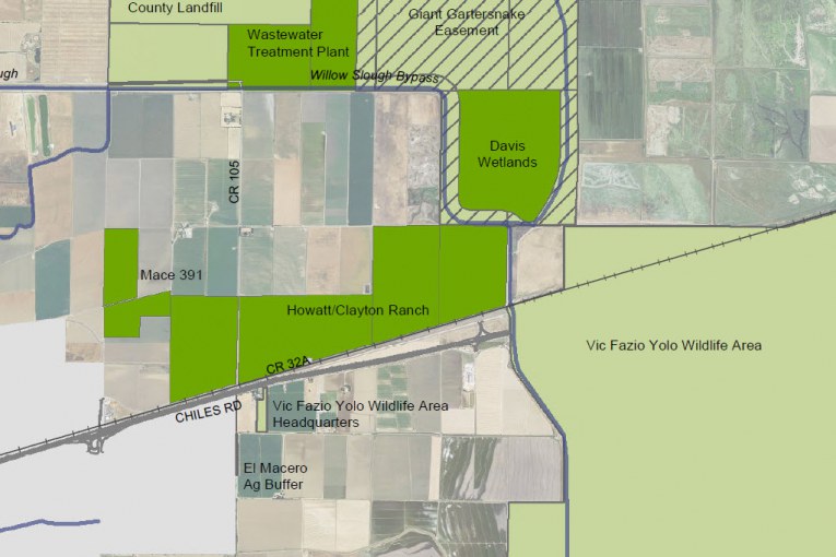
Right now the proposed development is surrounded to the north and east by the 391-acre Mace 391 property, which the city worked to put into a permanent agricultural easement. To the east of that property, along I-80 and moving into the Vic Fazio Yolo Wildlife Preserve, is the 775-acre and city-owned Howatt Ranch property that, in the past, the city has looked at as a possible sports park site.
Mr. Ramos has been discussing the possibility of purchasing that property, using that as mitigation land, and turning it over to the non-profit Center for Land-Based Learning where they promote farmland practices that would help preserve the land as open space and farmland in perpetuity.
Councilmember Rochelle Swanson told the Vanguard that she is supportive of the concept. “It is completely consistent with what I have been talking about from day one, we need to be utilizing an opportunity to lock up our land in a conservation easement.”
Ms. Swanson has always been bothered by the city’s open space program that has allowed mitigation land to be scattered, far from city boundaries, rather than in land that has a real possibility to be developed.
“When I first voted for the open space, the idea it was going to be in Davis – right around Davis, not all over the county,” she pointed out.

Dan Ramos told the Vanguard that this is a way to move the mitigation right to areas next to the city as well as close to the property itself. Not only that but, by turning the land over the Center, he would avoid having to purchase land from a farmer and then allowing the farmer to continue to farm and harvest that land for profit.
Center for Land-Based Learning Director Mary Kimball told the Vanguard that they have been working with the development team for some time. The plan has evolved from one that was conceptual to one that now has a specific property attached to it.
Currently, the Center leases its land, which she said “has been an incredible opportunity, but it’s also quite limited.” She said there is only so much land that they can lease from Craig McNamara and his family, and they have run out of room. “This is an opportunity for a much longer term plan in terms of our organization.”
This location would allow the Center to be headquartered in Yolo County, where they are currently in Solano County. And it gives them the ability to own land and be able to build headquarters. It will move their vision forward in “ensuring that farmland is responsibility and sustainably managed.”
The process is long and complicated. Dan Ramos would have to purchase the property from the city – which provides a benefit of additional money for the city. He then has to put the conservation easement on the land, which in itself a process. He would then donate a portion of it, in fee and title, to the Center for Land-Based Learning.
None of this would happen until the voters approve the Measure R vote. They are required to put at least a 2 to 1 ratio into the conservation easement.
Ms. Kimball pointed out that, if the land is not permanently preserved in an easement, “that could change in one council meeting. I think it’s in the best interest of the city quite honestly to make sure that land (is preserved).”
She noted that “the concept of nexus” was important to this discussion, “the closest possible land to where the conversion takes place from a legal perspective… that’s the ideal situation.” She stated that “this land is the closest possible land to the conversion that does not yet have a conservation easement on it.”
She called it “an incredible opportunity to lock this land up.”
Still, there will be some who question the use of city land for mitigation.
From the city’s perspective, this will not cost the city any money. If the project and easement get approved, the dollars will actually go to the city. “The city will actually make money by putting a conservation easement on this parcel,” she said.
She added that “there is no request in our proposal for the city of Davis to be putting any money towards this of any kind.”
While the devil’s in the details, Councilmember Swanson sees this as a potential “win-win” for the community, the developer and the Center.
Some will undoubtedly question this decision. They will argue that this was land that was already owned by the city and therefore there was no real threat to develop it. Councilmember Swanson pushed back, noting that there is no current easement on the property, and “it only takes three to change anything if there’s not a conservation easement on it.”
She believes that the Mace Ranch Proposal overall is “an opportunity for us to really work with ag-related research and development, along with other innovative businesses that will be there. I think being able to have research lands and farmlands adjacent to the innovation is how it should be.”
“It really would make us an incredibly strong community,” she added.
There are those who have clamored for 3 to 1 ag mitigation. The Vanguard reported last month that the county has moved to 3 to 1 mitigation in some circumstances and some believe the city should do the same. With 775 acres, the Howatt Ranch could accommodate 3 to 1 ag mitigation while turning the land over to a non-profit that specializes in sustainable agriculture.
Mr. Ramos sent the Vanguard a proposal that highlights the fact that ownership gives Land-Based Learning the opportunity to:
1) Properly steward the land – utilizing sustainable farming practices demonstrated at the Farm on Putah Creek, that we teach via our many youth programs and to new farmers in the California Farm Academy (CFA) program. The current situation is that the property has been leased to multiple farmers using year-to-year leases, thereby not allowing for proper soil and land stewardship practices to be implemented
2) Habitat restoration – implementing the many conservation/habitat projects that we have piloted and implemented for years at the Farm on Putah Creek and throughout the state via SLEWS (hedgerows, vegetated buffers, riparian restoration, pollinator habitat, etc.)
3) Farmland conservation and beginning farmer access to land – showcasing the ability for private landowners to conserve farmland through conservation easements, and then make that land available for beginning farmers for access
4) Beginning Farmer Training and Incubator – The California Farm Academy manages 5 acres at the Farm on Putah Creek, 7.5 acres in West Sacramento, and 5 acres in Davis; we need additional acreage so that our incubator farmers can scale up to increase production if they desire
5) Connection to Bypass/Wetlands – ability to connect to City of Davis/Conaway Ranch wetland projects via education and additional restoration potential
6) Farmland conservation – owning land that is under agricultural easement, thereby showcasing the opportunities for such easements to properly steward and provide land access to beginning farmers at appropriate prices for the next generation. Many Land Trusts are looking to partner with beginning farmer training and incubator programs, as their missions are very much intertwined. So far, there are no examples/case studies of this kind of partnership in Yolo County (via Yolo Land Trust), and this could be the first – allowing all of us to learn and scale it in the region as appropriate
7) Locate Operations – build a new headquarters (farmhouse and main office) at a location that is accessible and visible in the region
8) Agricultural Leasing – leasing additional land to area farmers for larger-scale agriculture (lease payments would support the entire facility for long-term maintenance and operations)
Right now this is just a concept that Dan Ramos and his team continue to explore. Measure R requires 2 to 1 ag mitigation, and the only question is where and what form.
—David M. Greenwald reporting


Then I read this from the Nishi article:
Would the city have to change the law?
No the city would have to sell the land to the developer.
Okay, got it. So basically we would be selling our land to the developer who would put it into ag mitigation just because we can’t trust our city councils to never develop on the land?
It’s more complicated than that.
David:
“It’s more complicated than that”.
Please elaborate.
In due time.
Sounds like BP hit the nail on the head. What’s stopping the city from putting the land in ag preservation now if it wanted to. Sweet deal for Ramos.
Nothing is stopping the city from doing that. I don’t see this as a sweet deal for Ramos if he’s paying market rate for property in that location. But I need to learn more.
NoName:
Indeed, why doesn’t the city do this (on its own), now?
There’s two good ways I think one can look at this. The city would have the land put into ag mitigation and receive a windfall from Ramos for the sale of the property. A win-win
The other scenario could be the city preserving the Howatt land themselves and still have an additional 500 or so acres put into ag mitigation that Ramos would be required to purchase. Another win-win with more land going to preservation.
BP:
At this point, I’d prefer that the city initiate an agricultural easement on their own land, without involvement from a developer. (Unless the city is still planning to put a sports park on the property, which is also a worthwhile goal.)
For me, anything that the developer proposes is a non-starter, if they insist upon housing at MRIC.
Ron, I totally agree with everything you wrote. A sports complex, soccer fields or just the city preserving the land for open fields themselves is preferable to me and still require Ramos to purchase additional ag land.
Just like there’s nothing stopping the city from putting its land in ag preservation, there’s nothing stopping Ramos from acquiring ag mitigation land, as required, and turning it into his vision of farming nirvana. Getting to buy city-owned land just saves him a lot of work and, I suspect, money.
Because that action would be fiscally irresponsible. You don’t throw away multi-million dollar assets when you have tens of millions in unfunded obligations.
Mark:
“Because that action would be fiscally irresponsible.”
The cost of conservation easements is far less than the residual value of the land. The land would retain monetary value, and can generate income through farming operations, etc. It is an asset that can provide monetary (and non-monetary) benefits for our community.
Selling the land to a developer could also be viewed as permanently “throwing away” a valuable asset. It would also result in the loss of a conservation easement on other (presumably privately-owned) farmland.
A sports park would, of course, cost money. (I’m not sure if this is the primary reason that the city acquired the land.) However, if we simply want to avoid costs and maximize profit, why don’t we just develop every square inch of publicly-owned land that has a potential market value for development?
I’m not going to support the destruction of open space/farmland, to satisfy unfunded obligations.
Ron: My understanding is that the City was forced to acquire the land during a flood plain dispute. I don’t remember the details.
My recollection – which could be wrong – is that runoff from the Mace Ranch development was flooding Howatt Ranch, the property owners sued, and the City was forced to buy their property as part of a settlement.
This will be a fascinating story to unravel. The City has owned the land since Jan 2003.
CalAg… you have part of the history correct… the rest is untrue… too late (early) to get into details…
They would be wrong. “Owned by the city” most certainly does not mean there is no real threat to develop it. In fact, the threat is ever-present.
This is a brilliant idea.
More greed and can kicking on display from the old people.
Not only do we saddle future generations with mountains of public debt and piles of unfunded liabilities, we eliminate thousands of acres land that future generations might need for economic development, even though future generations might prefer that land use over the what the current generation of older people prefer.
It is any wonder that Bernie Sanders and Donald Trump are popular these days? The elites can’t even be satisfied destroying economic opportunity today… they have to make sure it is completely eliminated for future generations.
Rochelle Swanson is an old person?
Older.
Think about it. 20 years from now we will probably have CC candidates that are 5-10 years old today. What will they think about the farmland moat 20 years from now?
Some might like it. Some will likely not like it.
But what stinks is that we would have taken away their choice to determine what land use is the best fit for them at that time.
We have Measure R. And because we have Measure R it is clear that Measure O is just a tool of the old land preservation and farmland preservation and nogrowth extremist activists to push their stuff on everyone else.
That is is the essence of greed and can-kicking.
A 2:1 mitigation has to occur on some land somewhere. Is there another site you’d prefer?
This is your knee-jerk trolling garbage rhetoric that achieves nothing. Unless maybe it makes you feel good. If you don’t like Measure O, put it on the ballot.
Don Shor: “Rochelle Swanson is an old person?”
Compared to you or me, no. Compared to someone fresh out of college and just starting their professional life, yes.
So should no generation ever be able to preserve land because some future generation might want to build on it?
Maybe if we did not have Measure R because Developers have a way of influencing CC decision-makers.
But since the city needs a majority of voters to approve any annexation, it is an extremist move to lock away peripheral land in permanent ag easements. You and I will be dead in a few decades I assume. Why do we get to choose the land-use fate of future generations when we won’t even be here?
Interesting point about that. I’ve never seen a subdivision or commercial development torn down and returned to farming. But I’ve certainly seen lots of land converted from farming to subdivisions and commercial development.
Have you decided yet which other parcel you’d like Ramos to use for mitigation if this isn’t acceptable to you?
I think we should bulldoze 5th Street. It apparently isn’t safe for driving or riding your bike on, so why not return it to farmland? Might hurt your business a bit Don, but this is Davis and we don’t care about businesses anyway. We can knock down City Hall as well since nobody apparently uses that space productively anymore. That should save us some bucks on compensation while we are at it. Maybe we should just bulldoze the entire town. Nobody has a right to live in Davis, after all.
So it stinks that the current young ‘uns won’t get to decide the fate of Mace Ranch Park, and Wildhorse? Because when those land use decisions were made, they were effectively permanent, just like a conservation easement. Could it be that the only permanent land use decision you like is one that involves urbanization?
Although I respect and admire her dedication and effectiveness in promoting her values and goals, it is a cold day in Davis in July when I find myself in agreement with Rochelle Swanson. I think that day may have arrived. This is an intriguing idea and I eagerly await more information. Right now, it looks like it could truly be that elusive win-win with a true collaboration between city and developer.
From the MRIC Notice of Preparation (the document that initiates the EIR process):
http://cityofdavis.org/home/showdocument?id=376
It appears that at least part of Howatt Ranch is already in a conservation easement.
CalAg, to the best of my knowledge (which could be wrong in this situation) there is no existing easement on any of the Howatt Ranch acreage. If my knowledge is correct, then the wording in the MRIC Notice of Preparation document is incorrect.
718 is a pretty specific number. Did someone just make it up?
I do not know. I have taken the parcel sizes from the County website to try and give some imputed meaning to the 718 acres statement “The Mace 391 and Howatt permanent agricultural easements, totaling 718 acres, are adjacent to the north, northeast, and east of the site”
The Mace 391 portion of that can be summarized as follows:
84.83 Mace 391/Arkansas Upper Parcel
235.86 Mace 391/Arkansas Lower Parcel
70.81 Mace 391/Arkansas Middle Parcel
391.50 Mace 391 Total
-25.34 City Holdback
366.16 Net Mace 366 bordering parcel
718.00 Notice Language
351.84 Calculated remainder
That calculated remainder needed to get to 718 does not match up with any combination of the three Howatt Ranch parcels
198.00 Howatt Ranch East Parcel
248.56 Howatt Ranch Middle Parcel
327.04 Howatt Ranch West Parcel
Thanks for looking up the parcel sizes.
718 = 391 + 327 (Howatt Ranch West)
Interesting observation. The numbers work that way, but the facts on the ground deviate from those numbers by the amount of the 25 acre hold back by the City.
This is nonsense. I don’t have a position (yet) on this, but I don’t like these sorts of manipulative arguments.
It also only takes three votes to put a conservation easement on the property immediately – a Council majority doesn’t need RAMCO to do it.
So let’s see, Swanson is a “yes” and I’m pretty sure the community can count on, at a minimum, Lee and Davis. So why not lock it up now while land prices are through the roof.
Regarding the proposal, the devil is always in the details. If the council is going to sell the property at market rate to the developer (and that means current prices for orchard ground), then I’m probably a supporter. If there’s a scheme to sell it at a discount because of the CLBL connection, then I’m a strong opponent.
At today’s values, the property is worth maybe $15M or more on the open market with a conservation easement. Perhaps the City should auction the property. I assume the fiduciary responsibility of the City Council is to maximize the value of this asset, not subsidize MRIC.
CalAg, for discussion purposes only (too many unknown details) it appears that this proposed transaction is more than simply converting a non-eased parcel into a parcel with an easement. The proposal appears to also have Ramos purchasing the three parcels (773 acres in total) from the City in the sa,e transaction that places the easement terms on the deeds of the parcels. If the purchase price is the same $10,657 per acre that the City received at the time of the Mace 366 sale, then the proceeds to the City would be approximately $8.2 million. If the purchase price is $15,000 per acre, the proceeds to the City would rise to approximately $11.6 million.
In addition, it appears that Ramos would transfer the ownership of the eased 773 acres to the Center for Land-Based Learning . . . an outcome that has value in its own right.
If the City were to go through the easement placement process for the 773 acres, they would then need to find a buyer (like they did with Mace 366), and that buyer would almost surely be purchasing the land to farm it themselves, so Center for Land Based Learning would be out in the cold.
Again, I share the above for discussion purposes only.
$8-12M would be a fire sale and finding a buyer would not be a problem.
My guess is that the best fiscal outcome for the City would be to auction the land to the highest bidder. If RAMCO wants to buy it and use it for ag mitigation, then great.
According to the Enterprise, they are offering CLBL a 50 acre farm on road 105 and Howatt Ranch would be leased as research fields to agribusiness companies.
Because of the nut farming craze and reasonable water supply in this area, class 1 and 2 farmland is up around $10-15k per acre last I checked.
The land on the NE quadrant of the cactus corner intersection that is currently being planted as an orchard sold for $23,750 an acre in August. This is not an outlier for this region of the central valley.
Using this comp, Howatt Ranch would be valued at $18M.
Wow. That’s nuts!
CalAg, if I have the right parcel 137-140-013 at 37880-37884 Russell Boulevard, it is a total of 9.823594 acres. Google Earth shows a house and at least three farm out-buildings. Those “improvements” would bring the value up considerably above simple orchard land.
This particular example is 160 acres.
My bad. I checked the NW quadrant of the cactus corner intersection rather than the NE corner. All I can say is WOW!!!!! Back when Mace 391 was happening I spoke to the owners of that parcel, who were a San Francisco-based development financing company. They got ownership of that parcel in a foreclosure settlement with Al Smith’s heirs. They clearly wanted to sell, but their price per acre was $100,000. $23,750 per acre is a major pricing come down for them. Do you know who bought it? Given its location, the price is almost surely not purely farm acreage value.
Rule of thumb – When you ask an owner the price of a $1 asset and they tell you $5 … they don’t actually want to sell. An owner will sometimes throw out a ridiculous number and take it if someone is stupid enough to do the deal.
Fire sale for ag land with a permanent conservation easement on it? What is your basis for a higher price?
See above. Howatt Ranch is in the flood plain and is not in the path of development. A conservation easement at that location isn’t worth more than $6K per acre max (maybe less because of Mace 391).
So everyone can follow your thoughts, how does the value of a conservation easement on an agricultural property differ from the value of that property as farmland?
You can pay a farmer to put a deed restriction on their property that forbids future development. The land retains it’s intrinsic value as farmland. That value, for anything that might support an orchard, is now north of $20K/acre.
Since in this case the property owner is the City, how would that work?
Sure is interesting that the proposed uses of the Ag Land is supposed to be Ag mitigation, which I guess is construed as “Sports parks and Farm Training HQ”. Even the Wildlife Area does not have buildings ON the property. But a property bought for flooding problems, is now a place to build things?
The other thing is the price as everyone on this article talks about is like it is NOT freeway frontage. Incredible, as in “hard to believe”. You want to sell it for what you bought it for a dozen years ago? Can I buy a house in Davis for what it costs a dozen years ago?
Pretty soon it will have a sound wall, flood plains will become raised fields like the miles of freeway frontage by the airport. HOW the CC can be so naive, or the rest of the people to say this is great are only thinking of themselves? Either Davis wrote Measure R to be obeyed, or it is to scare potential developers, except those who can work the system, like the Davis CC.
I’ve never thought much of any ecological land acquisition schemes where the government or developers buy land that is in little or no threat for development or spoilage.
Always ask: who is benefiting?
Alan wrote:
> Always ask: who is benefiting?
When I worked in politics we used the term “cui bono?” and more often than not the people “benefiting” are the people who give politicians money…
Normal
0
false
false
false
EN-US
X-NONE
X-NONE
/* Style Definitions */
table.MsoNormalTable
{mso-style-name:”Table Normal”;
mso-tstyle-rowband-size:0;
mso-tstyle-colband-size:0;
mso-style-noshow:yes;
mso-style-priority:99;
mso-style-parent:””;
mso-padding-alt:0in 5.4pt 0in 5.4pt;
mso-para-margin-top:0in;
mso-para-margin-right:0in;
mso-para-margin-bottom:8.0pt;
mso-para-margin-left:0in;
line-height:107%;
mso-pagination:widow-orphan;
font-size:11.0pt;
font-family:”Calibri”,sans-serif;
mso-ascii-font-family:Calibri;
mso-ascii-theme-font:minor-latin;
mso-hansi-font-family:Calibri;
mso-hansi-theme-font:minor-latin;}
A few corrections to the article are needed. This idea isn’t innovative, it’s deceptive.
Maybe I’ve missed something in 30 years of land conservation, but I have never heard of a private developer buying a conservation easement on public property. Howatt Ranch is already protected, owned fee simple by the city. Mitigation should be, as it always has been, directed at protecting private lands which are at risk of future development.
In addition to its public ownership, Howatt Ranch has greater protection than just a Council vote. At least part, if not all, of the land mapped as “Howatt/Clayton Ranch” is zoned agriculture. Converting any land (public or private) zoned as agriculture to urban use would require a Measure R vote. Exceptions to this are lands to be used for public schools, public parks, public infrastructure, or limited fair-share housing. The County Zoning GIS shows that the eastern two parcels of this Ranch are currently zoned as agriculture, but the western parcel has no zoning listed. The protection for all of Howatt Ranch by Measure R can be provided, without any real estate transactions, by ensuring all of the land is zoned agriculture.
Someone more familiar with land use regulation might find fault with this type of land protection. But if so, it should alarm open-space advocates. If City-owned agricultural lands are truly at risk of development without a citizen’s vote, even with this zoning, then all lands purchased by the City for open-space, such as through the use of Measure O, are at similar risk.
Measure R says nothing about mitigation requirements. It is Article 40A.03 FARMLAND PRESERVATION of the City Municipal Code that requires mitigation for loss of agricultural land as a condition of approval for any development project. It requires at least 2:1 mitigation, but location factors may result in ratios greater than that. It is an innovative approach that provide incentives for locating such mitigation lands close to the city. Check it out.
There are many other private lands on the edge of the city that could be purchased for mitigation. Just just look at the map in the article.
So why not work with those private landowners, instead of Howatt Ranch? Probably because it is easier to convince the city of a warped deal than to work with private landowners. It’s the same challenge the City has faced trying to purchase urban-fringe land for open-space. Landowners have to be willing to sell land at fair-market-value, that is, at low agricultural prices rather than higher speculative values. In 15 years since Measure O was passed, only one landowner on the edge of the city has been willing to do this, and that was the Bank of Arkansas trying to ditch Leland Ranch as fast as they could.
The statement that the open space city’s open space program has “allowed mitigation land to be scattered, far from city boundaries” confuses several different topics.
The open space program focuses on the use of conservation funding, not mitigating for development. Mitigation requirements are guided by existing laws and ordinances, as well as by willingness of landowners to sell land. In the 1980s and 1990s, the City was lucky to find willing sellers for mitigation lands along the city’s edge. These mitigation lands include Putah Creek Parkway, Road 102 and Willow Slough Bypass, west of city golf course, Wildhorse agricultural buffer and golf course, and east of El Macero Estates. Since 2000, this willingness to sell urban fringe lands has not been there.
Normal
0
false
false
false
EN-US
X-NONE
X-NONE
/* Style Definitions */
table.MsoNormalTable
{mso-style-name:”Table Normal”;
mso-tstyle-rowband-size:0;
mso-tstyle-colband-size:0;
mso-style-noshow:yes;
mso-style-priority:99;
mso-style-parent:””;
mso-padding-alt:0in 5.4pt 0in 5.4pt;
mso-para-margin-top:0in;
mso-para-margin-right:0in;
mso-para-margin-bottom:8.0pt;
mso-para-margin-left:0in;
line-height:107%;
mso-pagination:widow-orphan;
font-size:11.0pt;
font-family:”Calibri”,sans-serif;
mso-ascii-font-family:Calibri;
mso-ascii-theme-font:minor-latin;
mso-hansi-font-family:Calibri;
mso-hansi-theme-font:minor-latin;}
Open-space projects since 2000 have targeted urban fringe lands as a priority, among other priorities. Granted, these more recent projects have not been located along the city’s edge. But they are not “all over the county”. They are within the Davis Planning Area. The distance from the city’s edge is not by design, but due to reluctance of city-edge landowners’ to sell at fair-market-values. Any purchases above FMV would disqualify the project from state and federal grant matching funds, which the City has very effectively leveraged so far.