
By David M. Greenwald
Executive Editor
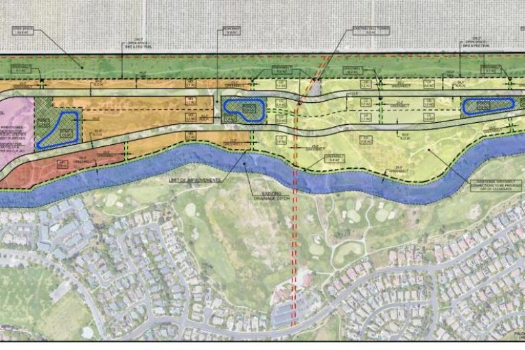
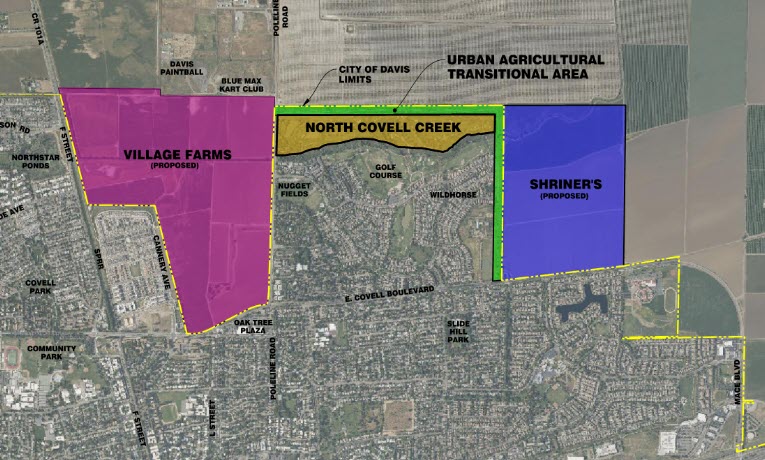
Davis, CA – A development group is proposing a new residential neighborhood—North Covell Creek—to be located within the current city limits along the city’s northernmost boundary on the north side of the Wildhorse Golf Club.
The project would convert the northern half of the golf course into residential neighborhood, while retaining the lower portion of the course and transforming it into a  comprehensive nine-hole golf course with a clubhouse, restaurant and driving range.
This would convert 74.6 acres of the golf course which is in the city limits into 500 to 750 homes of varying sizes and affordability levels.
According to the project proposal, “the reconfigured golf course will continue to serve as a physical separation between the Project and those existing neighborhoods to the south.” The applicants emphasized, “All residential units that currently abut the golf course will continue to do so.”

They also note that the conversion would help connect two other proposed projects— “the properties to the east and west are both owned by development interests and have pending applications with the City for residential development.”
It adds, “the proposed Shriner’s project (1200 units on 234 acres) is located to the east and the proposed Village Farms Davis project (1800 units on 390.5 acres) site is to the west. As a result of the current and planned land adjacent uses, the project is in an area appropriate for residential use and is a logical growth area.”

The plan, as indicated, is for between 500 to 750 units of varying levels of affordability with both for-sale and rental units.
The applicant notes that “the Project will maximize densities on its western edge and then progressively decrease in density as the neighborhood moves to the east. Focusing the density along Pole Line Road will maximize the number of residents that live a short walk to transit stops and nearby amenities, thereby encouraging the use of public transit and non-vehicular transit modes; it will also help to gradually reduce the traffic volumes away from major roadways thereby improving neighborhood safety and lessening VMT.”
They continue, “The high-density areas would include both for-rent and for-sale homes to meet a variety of household needs, this area would also include deed restricted affordable housing.”

The affordable housing component would call for between 73 and 110 units “depending on the total number of market-rate units that are ultimately incorporated into the Project.” However, the applicant noted, they intend “o commit in the Development Agreement that the Project include no less than 110 deed restricted units, thereby assuring the maximum number of affordable units that could be required per the City’s Affordable Housing Ordinance.”
They add that the applicant “intends to fulfill its affordable housing obligation onsite within the portion of the Project zoned for multi-family. The units may be provided within buildings that are all-affordable or within mixed-income structures.”
The applicants are proposing to replace the 74.6 acres of conservation easement “will either (1) identify an alternative property that the City deems to be equivalent or better and place it under a conservation easement, or (2) will pay into the City’s open space fund so that the City may pool the Project-generated funds with its existing funds to obtain a more desirable open space area.”
They emphasize: “The objective is to ensure that the Project results in no net loss of open space.”
As a property currently zoned for urban uses located within the city, there is no Measure J requirement.
The applicant believes that the location “represents a logical growth opportunity, provided that the site is within City limits, is located proximate to existing infrastructure and communities, and is situated between two proposed new-growth areas—Village Farms Davis and the Shriner’s Property—illustrating that the City’s peripheral growth is likely to occur in this area.”
Moreover, the property would “[u]tilize land located within the City boundary to meet future RHNA obligations.”


This would require approval by the easement owner, presumably the city and Yolo Land Trust. Has YLT given the nod for this? It would seem to run counter to their mission.
I got clarification on that. The Yolo Land Trust does not have a role in the golf course easement which can be modified by the city and owner. The easement is not a typical open space preservation easement which are held in perpetuity.
Isn’t that where the great coyote massacre of 2012 happened?
The good news is that coyote is one of the most adaptable species in California and that consevation easements appear to be fungible.
This is an interesting proposal. It certainly should produce helpful and informative discussion. David does appear to have his ear to the ground even more quickly than the City does. Thus far nothing about the proposal appears on the City website, so we will have to wait to hear more about it.
With that said, the information shared her does prompt two questions:
(1) Why does the roadway through the project parcel not extend from the western border all the way to the eastern border … providing through access to Pole Line from the east?
(2) It would be helpful to know the price points of the various Residential Product Types
___ (a) the 100 to 200 market rate single-family detached ownership units on lots larger than five thousand square feet in area.
___ (b) the 175 to 225 market rate single-family detached ownership units on lots smaller than five thousand square feet in area.
___ (c) the 50 to 100 market rate stacked condominiums or ownership units within a vertical mixed-use development.
___ (d) the 120 to 136 market rate rental housing developments with 7+units.
__ (e) the 55 to 89 below market rate rental housing developments with 7+units.
in area. (Section 18.05.050(a)(1)(A))
https://www.cityofdavis.org/city-hall/community-development-and-sustainability/development-projects/north-covell-creek
The proposal shows the road through the development that connects to Pole Line Road circles back and does not connect with the Shriner’s property and, most notably, does not cross the very popular and well used walking path along the east and north of Wildhorse. All things considered, that is a wise and smart thing to do. It retains the open space value and prevents a roadway that could become a new “commuter beltway” around the north edge of Davis. I would like to hear more from the golf course owners about their backstory on what they anticipate for the remainder of the golf course and club house buildings.
This application is outrageous. There is a conservation easement on this land which lasts into perpetuity. It would be a betrayal to the community if the City tries to find some way to circumvent this promise to the community that this land would be preserved as well as the habitat it protects. What next? Are we going to see the City accepting proposals to develop housing on our parks and greenbelts?
It’s bad enough that the City Council has now eliminated four much needed citizen-based commissions like the Tree Commission. This apparently is to be part of a plan to gut our citizen-based General Plan. And then there is their contemplation about trying to also gut Measure J/R/D, which is the citizens right to vote on ag land or open space lands proposed for development. Measure J/R/D was drafted and has been strongly supported by Davis citizens for over two decades because it is democracy in action. Measure J/R/D allows the public to weigh in to actually see what the project is being proposed to determine if it should be approved.
And now this outrageous proposal which is asking the City to renege on a commitment on a conservation easement which the community was promised by the City would be into perpetuity? It is hard to believe that this shocking scheme has been submitted as a proposal to the City.
According to the city, as I explained to Jim, there is not a conservation easement on the golf course. I’ll look further into it. I would also note that a golf course is one of the least environmentally friendly land uses we could have. Given the state’s mandates on housing, it doesn’t seem wise to try to pick and choose, but I guess we will see.
Yes, because everyone knows that paving over open habitat and lush recreational fields is a much more friendly land use.
You have multiple considerations – one is the existing land use, the other is the issue of VMT and access to transit.
https://www.cnn.com/2021/12/08/golf/climate-change-sustainability-spt-intl-cmd/index.html
With those things considered why stop at golf courses and open natural habitats? I’m sure there are several soccer fields and baseball complexes that could be paved over in consideration of VMT and access to transit.
The city has looked into redeveloping the Civic Fields, so that’s not so farfetched.
Someone just emailed me and pointed this out:
That’s a myth.
https://www.usga.org/course-care/water-resource-center/environmental-principles-for-golf-courses-in-the-united-states.html
My reaction to David’s comment was the same as Don’s, but without the benefit of the information provided in the link. Thanks to Don for sharing that link.
Not really a complete myth. For one thing Don used one of the most biased sources available. You would fully expect the USGA to portray golf courses as nothing less than friendly to the environment and climate change. Don cited a set of non-binding wishy-washy principles. There is no certification program that golfers can use to determine if courses are run using any of those principles. Golf is a want, not a need.
David,
Whom at the City, said that there is not a conservation easement? That is simply not true. There is a very clear Deed of Conservation Easement on the Wildhorse Golf Course protecting course into perpetuity.
What they said is it’s not a standard conservation easement, this one is held between the city and Gulf Course rather than the by a third party like Yolo Land Trust.
David, please take a look at the Deed of Conservation Easement for Wildhorse Golfcourse at this link. https://drive.google.com/file/d/1BgAWV_0qz4nFfagSkl2Vb01GkOUvoD4Y/view?usp=drivesdk
I’m not a lawyer but it sure looks like a Perpetual Conservation Easement. “forever conserving the open space character of the property”. “Grantee … preserve and protect into perpetuity…”. The grantee is the City of Davis.
I don’t know how the city of Davis staff could interpret the Deed any other way than as Perpetual Conservation Easement.
I just got a copy from the city. I think this is the operative section. Basically the grantor is the Golf Course and the Grantee is the city. And the city council could approve an amendment and change of use or nature during the a public meeting.
David, you may be correct, but won’t any use have to comply with the section about prohibited uses?
… and. https://www.davisvanguard.org/img_7874/
The first image link did not post correctly. Here is the correct link
https://www.davisvanguard.org/img_7874/
This proposal is the reason most conservation easements have two grantee agencies, each one with veto power over changes: to keep the other grantee honest.
It’s also the reason we have Measure J.
The thing we all seem to be losing sight of is the situation with the owner of the golf course. I’m not a golfer, but if I understand the situation, the Wildhorse Golf Course is a privately owned business. Why would the owner sell off half the golf course and one that has a good reputation, I am told, if there wasn’t a business reason? Is the golfing industry on the rise or is it in decline? Is there no buyer for a golf course here? Why sell half and have only half a golf course left? While I’m no fan of capitalism, there is an ownership issue under all of this that has not been addressed and the details may impact how the city or the community should react to the development. Seems we’re all shooting at some imaginary target in the dark here, folks.
My understanding is that they are in financial trouble.