by David M. Greenwald
Executive Editor
A new report released in late May by UC Berkeley’s Othering & Belonging Institute found that 95.80 percent of total residential land area in California is zoned as single-family-only—and that zoning has grave consequences for racial and income inequalities in the state.
The report finds that the result of this zoning is that it “severely constrains” the “spatial possibilities for denser and more affordable housing.”
That figure includes both incorporated and unincorporated regions of the state, which somewhat distorts the picture.
However, even when unincorporated regions (which include vast swathes of sparsely populated land) are removed from the calculation, they find that “82 percent of total  residential land area in the state is reserved for single-family housing.”
Single-family-only zoning averages 77.82 percent of residential land across 519 municipal and county jurisdictions, with a median of 83.93 percent.
However, crucially they find that a total of 91 jurisdictions have reserved more than 95 percent of their land in residential zones for only single-family units—which means that they effectively bar multi-family housing throughout their jurisdictions.
There is a huge racial impact in these restrictive zoning areas. It is exclusionary.
The report finds, “Although California is only 35 percent white, cities above 96 percent single-family-only zoning are nearly 55 percent white.”
The report represents the final and culminating report of a six-year investigation into the extent, correlates, and putative effects of single-family-only residential zoning in California.
They find, “Our examination of that issue made clear to us that restrictive land use policies – single-family-only zoning in particular – played a significant role in maintaining and exacerbating patterns of racial residential segregation in the Bay Area.”
They argue that “loosening such restrictive land use policies would be necessary to reverse levels of racial residential segregation in the future. “
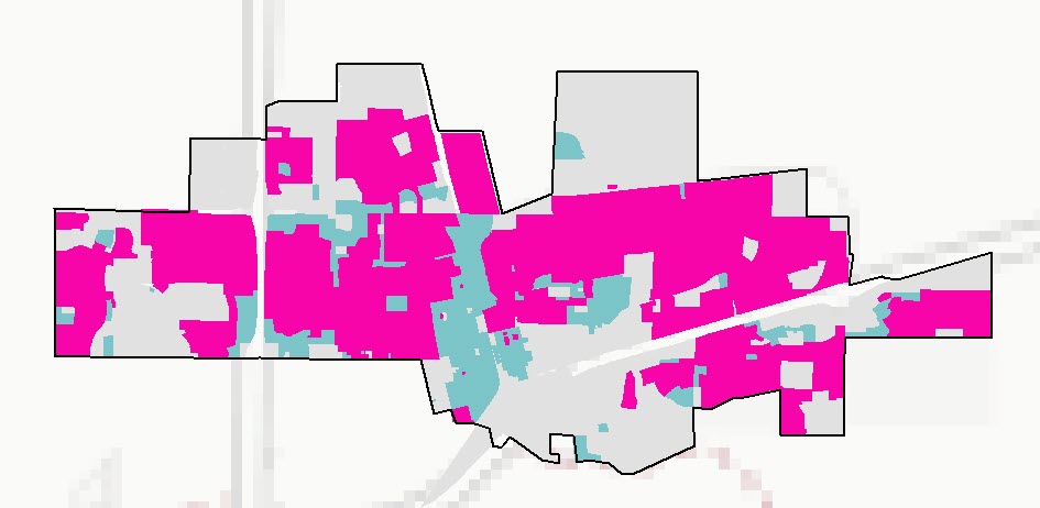
In 2022, they looked at the Sacramento region, including Davis. The pink represents single family residential in Davis while the blue represents other residential—largely in student housing corridors.
In the Sacramento Region, they found that 77.1 percent of residential land in the region is exclusively reserved for single-family housing.
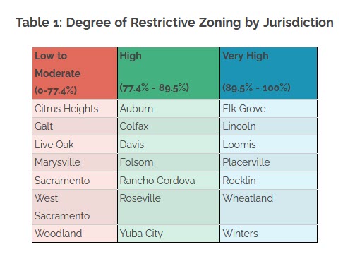
Even with the student populations, Davis falls squarely in the “high” range between 77 and 89.5 percent.
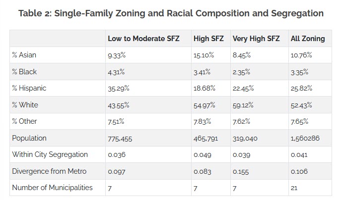
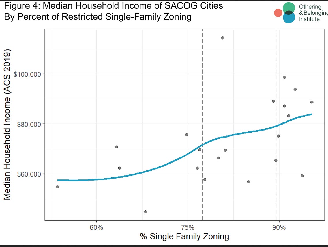
There is a “direct relationship (a positive correlation) between median household income and the percentage of single-family-only zoning by jurisdiction.”
Household incomes increase as the percentage of single-family-only zoning rises.
They also find a similar relationship between the percentage of single-family-only zoned areas per jurisdiction and median home values.
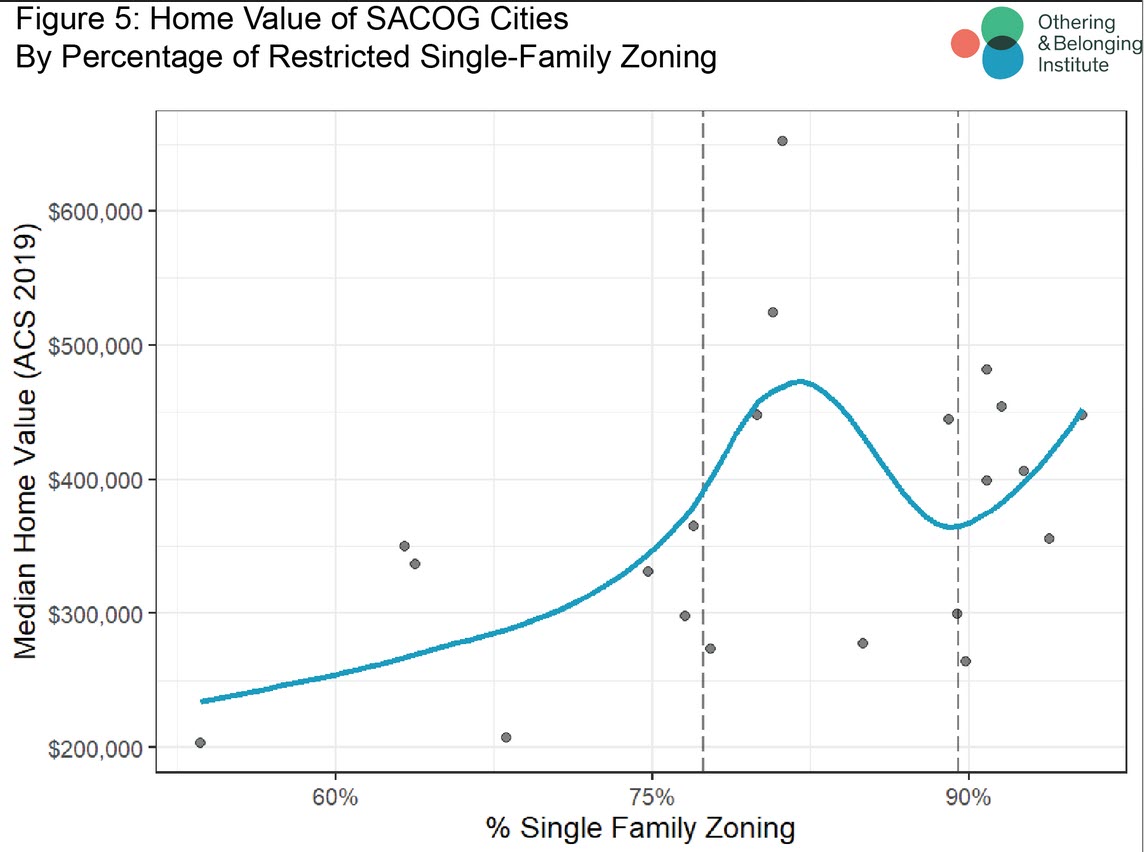
Here the researchers note that, while the relationship is clear, it is “not quite as stark as our previous reports. We find that median home value generally increases as the percentage of single-family zoning increases in a municipality.”
The exception in the middle category is due to Davis and its “unique circumstances.”
Davis represents the highest home value in the entire survey and in that middle section.
“Davis is home to the only University of California campus in the SACOG region. Housing development in Davis is limited by extensive floodplains that surround three sides of the city,” they write, missing some of the nuances of Davis’ housing policies. “This keeps housing supply low, although demand for housing in Davis is high due to the student population and the perceived desirability of the town. Because there are fewer jurisdictions in the region, Davis plays an outsized role in shaping the overall pattern.”
Full report: here
SACOG Regional report: here


Even with the student populations, Davis falls squarely in the “high” range between 77 and 89.5 percent.
When you look at the graphic provided https://www.davisvanguard.org/wp-content/uploads/2024/06/SFZ-2.jpg
77% makes no visual sense.
— the area of Davis west of 113 appears to be no more than 50% SFR
— the area east of 113 and west of F Street appears to be between 70% and 80% SFR with the portion below Covell being in excess of 90% and the portion north of Covell being less than 60%
— the area east of F Street and west of the eastern border of Wildhorse appears to be no more than 30% SFR
— the last area that is to the east of the Eastern border of Wildhorse looks to be at least 80% SFR
A Rough addition of those percentages, 50%, between 70% and 80%, 30% and 80% does not come close to being over 77%
They used software to map the zoning and calculate the percentages.
Here is their methodology: https://belonging.berkeley.edu/single-family-zoning-california-methodology-statement
Did you read this and then attempt to replicate their data and get a different result or are you trying to eyeball it and use anecdotal evidence to reach your conclusion?
They did not have any tables or calculations, other than the 81% that they came to as a total, but the flaw in that calculation is very clear to see … at least a third of the City is marked by them as unknown, which includes all of the apartments in West Davis, all of South Davis west of Danbury, and the whole University Ave neighborhood. They also don’t appear to separate attached SFR from detached SFR.
A realistic approach by them would have been to calculate the rental vs. owner occupied percentages. We know that that is somewhere near 50%-50% as opposed to 20% vs. 80%.
All they are looking at is zoning. They need to look at rental v owner, they are looking at the underlying zoning and calculating the percentage based on the zoning.
Understood David, but Davis presents a difficult challenge for them because so much of the City, probably more than 50% is zoned PD (Planned Development). If they had been thoughtful they would have excluded Davis from the study.
I thought SB9 eliminated single-family zoning in 2021.
Yes and no.
YIMBY’s 2023 analysis of SB:
Key takeaways:
SB 9 aimed to legalize duplexes and fourplexes in residential districts across California. Yet recent research suggests that many municipalities are adopting local ordinances that subvert the law.
The data largely reflects this: most of the municipalities surveyed didn’t permit a single SB 9 unit in 2022, while Los Angeles permitted fewer than 40 units—a far cry from the permitting boom we’ve seen with accessory dwelling units (ADUs).
I think if we asked the authors of this study, they would say that SB 9 has had a minimal effect.
This is from the city, the light yellow is residential, low density.