This Op-ed article was originally published in the Davis Enterprise on March 22nd in response to February 18th Davisite and Davis Vanguard articles in which Alan Pryor asserted that valid concerns related to contaminants associated with the proposed Village Farms Davis project, are “myths”.
There was a recent attempt to dismiss contaminant risks related to the proposed Village Farms project in north Davis. We herein summarize data and potential risks related to contamination from the adjacent Old Davis Landfill, Burn Area, and Wastewater Treatment Plant.
First, it was posited that contamination from the landfill has dissipated, per and poly fluoralkaline substances (PFAS) are not a health issue and that Village Farms Davis will not be built on the landfill.
Response
While the concentrations of analyzed volatile organic compounds associated with landfill have decreased over time, the EIR process did not adequately consider the contaminants associated with 30 years of burning of waste at the adjacent unlined Old Davis Landfill/Burn Site Specifically, dioxins and furans and higher molecular weight and carcinogenic polycyclic aromatic hydrocarbons (PAHs), such as benzo(a)pyrene, were not analyzed at the level of concern. Moreover, the boundaries of the burn site – as defined by the Department of Toxic Substance Control, include the extent of contamination generated by burning and disposal activities or by subsequent spreading of contamination by natural processes (such as wind, rain, flooding, and erosion) or human activities (such as grading and trenching) – are unknown and could include adjacent Village Farms property.
A key concern with the PFAS “forever chemicals” contamination documented at the project site is their presence in shallow groundwater and the potential for vapor intrusion. The extent of the PFAS shallow groundwater contamination has not been defined within the proposed development footprint adjacent to the landfill/burn site. However PFAS in the groundwater at the southern boundary of the Old Davis Landfill is as high as 1,600 parts per trillion (ppt) (measured in 2024), compared to 34 ppt in the groundwater under the middle of the Davis waste-water treatment plant (DWWTP) and 120 ppt in the DWWTP effluent (both estimated in 2021). PFOS, arguably the most toxic form of PFAS, is present at 1,500 ppt at the southern boundary of the Old Davis Landfill, 375-times higher than the target limit of 4 ppt in the DWWTP groundwater. The proposed drainage channel and residential property will be located within 100 ft of this location. The PFOS groundwater concentration was above this target limit on the Village Farms Property 1/3 of a mile away from its source at 39 ppt (measured in 2024). It is therefore highly likely that PFAS contamination is present in the shallow groundwater underlying the footprint of the proposed development south of the landfill/burn site.
EPA researchers[1] stated that “volatile per- and polyfluoroalkyl substances (PFAS) pose an inhalation exposure risk to occupants of buildings overlying a contaminated soil or a groundwater source.” There are also potential risk pathways via soil, food, surface water, and air[2]. Elevated groundwater PFAS concentrations at the southern margin of the landfill/burn site and upgradient of the project footprint are associated with the 4+ acres most recently used as a waste disposal site between June 1973 and July 1975 according to records at www2.calrecycle.ca.gov/; a time period that corresponds to the introduction of many disposable products containing these PFAS forever-chemicals.
Second, while it was acknowledged that there is potential infiltration of groundwater containing PFAS into the channel which is proposed at the boundary between the project footprint and the landfill/burn site it was stated that the channel depth will be above the maximum water table ever recorded and that the new channel will be lined with an impervious compacted clay layer to prevent any infiltration of groundwater into the Channel.
Response
The Partial Draft Response to EIR Comments stated that the proposed channel would include a geotextile or low permeability liner, not an impervious clay layer. Moreover, the infiltration rate of this proposed liner is listed at 2.4 X 10⁻⁵ inches per minute. To be effective at limiting PFAS migration into the proposed channel, this infiltration rate would need to be significantly lower than that of the subsurface clayey soils at Village Farms that conduct PFAS laden groundwater. However, the liner is unlikely to be effective because its infiltration rate is similar to those of clayey soils present on site.
Figure 4.8.3 of the Draft EIR show multiple events in which measured groundwater levels were at or above 26.5 feet above mean sea level which is the proposed channel depth thus indicating that groundwater levels periodically can be shallow enough to allow contaminated groundwater associated with the Old Davis Landfill/burn site to flow toward and into the proposed drainage channel. Groundwater levels in monitoring well HLA-MW-1 which is located at the southern boundary of the landfill and adjacent to the proposed canal were measured at or above 26.5 feet on 9 occasions based on data collected from 1992 to 2024 and reported in the 2024 Geochon report[3]. These and other data collected in the vicinity indicate that groundwater levels can remain elevated for months. Moreover, if it were possible to limit groundwater flow to the channel, this would likely cause higher PFAS-containing groundwater levels on adjacent properties. Geochon[4] recommended “that the proposed channel be designed with a base elevation above the groundwater elevation to limit the infiltration of groundwater into the channel that may be impacted by PFOA.”
The movement of PFAS to the proposed channel represents a potential threat to the ecosystem. Scientific studies demonstrate that exposure to PFAS in the environment may be linked to harmful health effects in humans and animals (https://www.epa.gov/pfas/pfas-explained.) Experimental studies that have revealed the long-term effects on animals include the alteration of thyroid functions, and the ability to induce carcinotoxicity[5]. PFAS are persistent in the environment and accumulate in the food chain[6].
Elevated selenium concentrations in shallow groundwater also represent a potential threat to the ecosystem. Concentrations in groundwater samples in 2024 ranged from 5.1 to 68 micrograms per liter. For comparison, a 0.2 microgram per liter level is recommended for protection of aquatic life in the Bay and Delta (https://epa.gov/wqs-tech/water-quality-standards-establishment-revised-numeric-criteria-selenium-san-francisco-bay).
We posit that further investigation and analysis are needed to adequately assess and mitigate the human and environmental health risks associated with the proposed Village Farms development adjacent to the landfill/burn area.
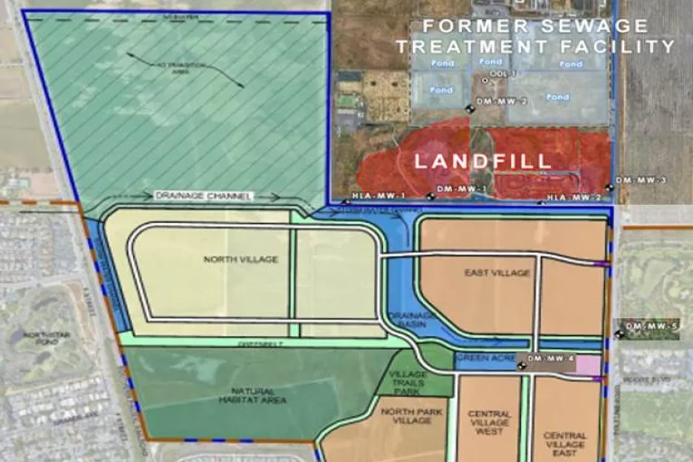
The following map from the Draft Environmental Impact Report which was not included in the Davis Enterprise Op-ed article shows Village Farms proposed drainage and housing adjacent the Old Davis Landfill/Burn Dump and Sewage Treatment Plant and monitoring well locations. The liner discussed in the Davis Enterprise op-ed article and the Partial Draft Response to EIR Comments does not appear in the Development Agreement or Baseline Project Features.

[1] Schumacher et al., Journal of hazardous materials, 464 (2024) 133025
[2] Ahrens et al. (2011). Environmental Science & Technology 45(19): 8098-8105
[3] Geochon Consultants, Inc., 2024, Drainage Channel Evaluation prepared from North Davis Land Company
[4] ibid
[5] Peritore et al. , International Journal of Molecular Science, 2023, 24, 11707
[6] Houde et al. , Environmental Science and Technology, 2011, 45, 7962-7973
Steven Deverel, Ph.D. Professional Geologist and Certified Hydrogeologist, community technical advisor for the Frontier Fertilizer Superfund site, 1995 – 2022.
Marjorie Longo, Ph.D. Emeritus Professor of Chemical Engineering
Robert Okamoto, Retired Staff Air Pollution Specialist, former working group member that identifies significant adverse impacts on public health or environment, including air, water, or soil.
Its an old enviro trick to say more study is needed.
Notice that all the authors really state is that there is contamination in the groundwater and it theoretically “COULD” seep into Channel A and theoretically “COULD” migrate to the Yolo Bypass where it theoretically “COULD” accumulate sufficiently to harm wildlife.
But the authors are all bright people, why did they not calculate and quantitfy the ACTUAL risks of such events occurring and the resultant ACTUAL concentrations of the contamination that might accumulate in the Yolo Bypass.
The reason they did not report this information is because the actual risks of contamination in the Yolo Bypass from groundwater contaminants arising from the Old Davis Landfill are infinitesimally small. But reporting that would defeat the scare tactics employed in this article. As such, this is not a thoughtful, deliberate scientific report. It is yellow journalism pure and simple.
Much more to come in my own upcoming article on the “real risks” of PFAS contamination in Yolo Bypass. (Hint – It is not the groundwater from beneath Village Farms Davis. It is our very own Davis Waste Water Treatment Plant we should be worried about).
According to the DEIR, “…substantial evidence exists to conclude that potentially contaminated groundwater from the Old Davis Landfill would not come into contact with the Proposed Project/BRPA storm water system. As a result, substantial evidence exists to support the conclusion that the project’s runoff would not transport contaminated water into the downstream system.” – DEIR (4.8 – 23). Also see Channel Evaluation Report “.
Alan, it sounds like the firm performing the EIR did not include the Geosyntec/Central Valley Regional Water Control Board finding in their EIR considerations. Were they unaware of that Control Board investigation workplan? Or did they dismiss it as irrelevant? If they dismissed it as irrelevant, did they explain why they did so?
Alan Pryor said … Notice that all the authors really state is that there is contamination in the groundwater and it theoretically “COULD” seep into Channel A and theoretically “COULD” migrate to the Yolo Bypass where it theoretically “COULD” accumulate sufficiently to harm wildlife.
Alan, you have been an active party to several Sierra Club lawsuits that firmly relied on the word “could”. Why was that approach good enough for you in those Sierra Club legal proceedings, but not good enough for you in this current situation. Your arguments smack of a double standard.
While we are talking about “could” … is there a reason why the vernal pools section of the project site isn’t being put into a permanent habitat conservation easement? Not doing so leaves the door open to the possibility that the vernal pools COULD be destroyed and urbanized sometime in the future. Thoughts?
The Central Valley Regional Water Quality Control Board finds that more study is needed with respect to the landfill.
The 2025 Groundwater Investigation Workplan of the Old Davis Landfill states the following,
“Geosyntec Consultants, Inc. (Geosyntec) prepared this Groundwater Investigation Work Plan
(Work Plan) on behalf of the City of Davis Public Works Utilities & Operations Department (City)
for the closed Old Davis Landfill located at 24998 County Road 102, Davis, Yolo County,
California (the Site; Figure 1). In a letter dated May 21, 2024 the Central Valley Regional Water
Quality Control Board (CVRWQCB) requested that the City provide a work plan to further
characterize the extent of groundwater contamination originating from the Site (CVRWQCB
2024). This Work Plan was prepared in response to the CVRWQCB request. ”
“1.1 Objectives
The objectives of this Work Plan are to:
• Provide a Conceptual Site Model (CSM) based on the historical Site data.
• Install additional monitoring wells to further characterize the extent of groundwater
constituents of potential concern (COPCs) originating from the Site.
• Conduct a groundwater flow study to evaluate lateral and vertical groundwater flow and
potential migration of COPCs from the Site.
• Obtain information on the well construction details and operations of domestic and
agricultural water supply wells (supply wells) within 4,000 feet of the Site to evaluate the
potential for COPCs from the Site to affect the supply wells.
1.2 Plan Organization
Following this introductory section, the Work Plan is organized as follows:
• Section 2 “Conceptual Site Model” summarizes the site history, hydrogeology, COPCs,
and nearby supply wells.
• Section 3 “Implementation” presents a plan for the well installations, groundwater flow
study, and obtaining information on nearby supply wells.
• Section 4 “Reporting and Schedule” provides a description of the reporting activities and
a schedule.
• Section 5 “References” lists the references cited throughout this Work Plan. ”
“The constituents of potential concern (COPCs) at the Site include PFAS, which have exceeded
MCLs (PFOS, PFOA and PFHxS). The historical PFAS results are included in Table 3. The highest concentrations of PFAS are observed at A-Zone monitoring well DM-MW-1 adjacent to
Cell 1. PFAS have also been detected in the B-Zone at DM-MW-4 and DM-MW-5, and in the CZone at ODL-1…. ”
To see the details of the planned PFAS monitoring (including installation of new monitoring wells) withing approximately 1 mile of the Old Davis Landfill see the workplan at https://documents.geotracker.waterboards.ca.gov/esi/uploads/geo_report/9738538801/T10000021241.PDF
But nothing in this work plan speaks to the “risks” you are alleging exists. Have you not done any calculations estimating 1) how frequently groundwater MIGHT rise to purportedly be able to seep into Channel A, 2) how much groundwater MIGHT seep into the Channel if the groundwater rose, 3) what are the estimated concentrations of PFASs that MIGHT be in that seepage, 4) what concentrations of PFASs MIGHT result in the resultant water flow through Channel A, and 5) what concentrations of PFASs MIGHT exist by the time the water reaches the Yolo Bypass? Doing so will quantify the “risks” you are alleging MIGHT occur.
Risk is a function of exposure to a hazard over time, expressed in probabilities of particular outcomes.
Unfortunately, this article just describes the hazards, not the risks.
What are the likelihoods of exposure?
What is the likely dilution of the hazardous substance in the air or water?
How likely are those exposures to result in adverse outcomes?
Will proposed mitigations of exposure reduce the risk?
Those are the kinds of risk issues that regulatory agencies evaluate.
I wholeheartedly agree with what Don has said above. Those are questions that the Draft EIR should have specifically addressed, especially in light of the Geosyntec/Central Valley Regional Water Control Board’s finding.
as I said to Alan, it sounds like the firm performing the EIR did not include the Geosyntec/Central Valley Regional Water Control Board finding in their EIR considerations. which raises the question, were they unaware of that Control Board investigation workplan? Or did they choose to dismiss it as irrelevant? If they dismissed it as irrelevant, why didn’t they explain why they did so? And regarding Don’s questions, what were their answers?