
In a bold move, former Davis City Councilmember Michael Harrington has furnished a report from Daniel Smith, a traffic engineer with Smith Engineering & Management. He has reviewed “the portions of the Draft Environmental Impact Report (the DEIR) related to transportation and circulation for the Nishi Gateway Project (the Project) in the Davis, CA (the City).”
He writes, “My qualifications to perform this review include registration as a Civil and Traffic Engineer in California and over 47 years professional consulting engineering practice in the traffic and transportation. I have both prepared and reviewed the transportation and circulation sections of environmental review documents, including studies of similar developments.”
Just after midnight this morning, Mr. Harrington sent an email to Katherine Hess, among others, asking “that the City hold open the comment period while its consultant works on a report that addresses the valid technical concerns of Mr Smith. Then we would have another 45 days to comment.”
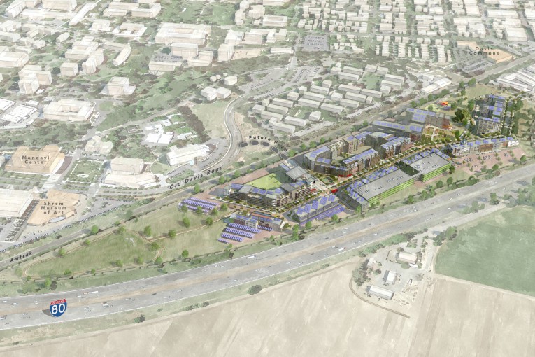
The city released the Draft EIR in early September. Today is the deadline for the submission of comments. The Nishi Gateway Innovation District is a collaborative planning process among the city, UC Davis and Yolo County, and is proposed on the 47-acre Nishi property adjacent to the city limits and UC Davis. The Innovation District also includes West Olive Drive and is designed to complement adjacent uses on the UC Davis campus.
According to the city’s release in September, the Draft EIR analyzes impacts that may result from development of the project under different circumstances, including full project buildout, no project, and several alternatives which provide additional important information and context for the community and council to consider.
The alternatives studied in the DEIR include examining research and development (R&D) only, alternative land use mix, and off-site (5th Street corridor) considerations. The DEIR addresses the impact of development of the 47-acre Nishi property as a mixed-use innovation district, as well as potential redevelopment of properties on West Olive Drive.
What Daniel Smith’s letter to Don Mooney dated October 25 offers is a technical analysis of the Nishi Draft EIR. He concludes, “It seems evident that the City has pared the content of the DEIR’s transportation section to make it more difficult for the public to understand and comment on it. Based on all of the foregoing, I am convinced the problems with the transportation and circulation section renders this DEIR unsuited for certification.”
Mr. Smith is critical that the analysis of the trip generation “are unreasonable and result in understatement of the Project’s external motor vehicle trip generation and consequently findings of impacts and mitigation needs.”
He adds, “Reliance on assumptions that unreasonably minimize the Project’s external traffic generation is inconsistent with the good faith effort to disclose impact that CEQA demands. The analysis should be redone with more realistic assumptions…”
Daniel Smith is also critical of the project alternative. He writes, “The analysis of alternatives has failed to consider one seemingly feasible alternative that could avoid much of the significant adverse transportation consequences of the Project as proposed.”
The applicant has proposed “to develop a grade-separated crossing of UPRR railway in order to gain access to Old Davis Road. This is a highly significant matter from perspectives of engineering, cost and agreements between the developer, City, University and the railroad and perhaps others such as the State Public Utilities Commission.”
Mr. Smith offers, “An alternative to develop an grade separated access beneath I-80 to West Chiles Road might be less costly and less administratively complex than the proposed Project access scenario 1 and would appear to have less adverse consequences on the critical Richards Boulevard corridor. This alternative should be added to the analysis and the current DEIR is inadequate for having failed to consider it.”
—David M. Greenwald reporting
The following are the full text of the technical comments by Mr. Smith:
Calculations Supporting Estimates of Existing Traffic Delay and Level of Service Are Not Provided.
Neither the DEIR nor its supporting appendices provide calculation sheets supporting its estimates of existing delay and level of service (LOS) on the various intersections and roadway facilities studied in the DEIR. Such information is customarily provided with DEIRs prepared under the California Environmental Quality Act (CEQA). Such detailed calculation information is vital in that allows the public to determine whether the calculations do or do not accurately represent existing conditions that are readily observed by the public – such as typical delays experienced on individual intersection approaches or typical queue lengths on those approaches. Unless the public has assurance that the analysis procedures accurately replicate existing observable conditions, it can have no confidence that these same procedures can accurately estimate delay and LOS in the future analysis scenarios that purport to measure the effect of adding Project traffic. This is particularly critical at traffic analysis locations in the Richards Boulevard corridor where the DEIR has analyzed traffic delay and LOS using traffic micro-simulation procedures (VISSIM). Unless the public has access to the full computational record, it cannot examine considerations that are critical to the credibility of the entire analysis including:
- Since final results of a simulation analysis are based on the average of a number of runs of the simulation, how many runs of the simulation were performed and how radically different or closely comparable were the results of the individual simulation runs from the average and from each other?
- Since the traffic entering the various movements in the simulation is generated by probability functions, the number of trips passing through each movement on a simulation run and the aggregate of all trips on that run may be different from the actual counted movements and their aggregate. Consequently, the data provided must address the question of how does the number of trips on the various movements on each run on the simulation and on the average of all runs compare with the actual movements observed in the existing traffic counts?
- How do delays and queues on the major movements in the simulation compare to delays and queues measured in actual existing traffic conditions?
If such information about the existing conditions analysis is not provided in the DEIR or its appendices, the public has no basis for confidence in the results of the analysis – not only in the existing conditions analysis but in the future scenarios that evaluate the consequences of adding the Project since those are built on the same techniques as the existing conditions analysis. Hence the DEIR is deficient as an information document. Moreover, since the missing information is so essential to intelligent comment on the DEIR, it is insufficient to supply it as part of the response to comment in an FEIR. The DEIR should be subject to an additional 45 day comment period following release of the appropriate information.
Furthermore, there is good reason for the public to regard the findings of the VISSIM simulation for the intersection of Richards and Olive Drive with skepticism. In 2011 the transportation analysis for the UC Davis Hyatt Place Hotel Expansion and Old Davis Road Extension Focused Tiered Draft Environmental Impact Report was performed by Fehr & Peers, the same transportation consultants who performed the transportation analysis for the current subject Nishi Gateway Project DEIR. In the 2011 study, those consultants found that existing delay and LOS at the Richards-Olive intersection was 24 seconds / LOS C in the AM peak and 15 seconds / LOS B in the PM peak. However, the 2011 report’s narrative noted the following:
“Although the 1st Street / Richards Boulevard and Olive Drive / Richards Boulevard intersections are reported to operate at an acceptable LOS with the peak hour traffic volumes used in this analysis, field observations indicate that these intersections often operate unacceptably during the peak hours. The HCM 2000 methodology used to analyze these intersections does not consider the effects of queuing that extends into adjacent intersections. This situation frequently occurs during the peak hours along Richards.”
Now, the same consultants, using the VISSIM simulation, say the same intersection, with slightly different 2014 traffic counts, report that Richards-Olive operates at a delay of 15.4 seconds / LOS B in the AM peak and 20.7 seconds delay / LOS C in the PM peak. Quite evidently, the VISSIM simulation employed in the current DEIR is no better at replicating the unacceptable conditions that exist in the peak hours at Richards – Olive than the earlier methods. This is a critical flaw in the analysis.
Trip Distribution
The narrative discussion on page 4.14-29 makes evident that the DEIR relied upon the City of Davis travel demand model. However, neither the DEIR nor its appendices present a representation of the actual trip distribution. A figure or table summarizing the trip distribution is a customary component of the transportation and circulation section of most EIRs where traffic-related issues are a concern. The lack of this information makes it difficult for the public to determine whether the trip distribution underlying the transportation analysis is reasonable or to assess whether the DEIR’s compilation of Project-generated Vehicle Miles Traveled (see subsequent discussion herein) is reliable. This is another example of how the DEIR is deficient as an information document.
Unreasonable Trip Generation Assumptions Understate Project Trip Generation
Certain of the assumptions made in the DEIR analysis of trip generation are unreasonable and result in understatement of the Project’s external motor vehicle trip generation and consequently findings of impacts and mitigation needs. These include the following:
- The trip generation analysis assumes that except, except for 210 ‘for-sale’ units and some 88 market rate rental units, all of the remaining 352 rental units proposed would be occupied by UC Davis students. Students at UCD make relatively few of their trips during the normal am and PM commute peak periods and make a very high percentage of their trips by walking, bike or transit. But unless these rental units are, as a condition of approval, required to be administered as reserved for student housing (current student registration required as a condition for continued rental), there is no guarantee that any particular percentage of them will be occupied by students. Examples of others who might rent these units include former students who have graduated and have jobs in the commutable region, but who like living in Davis and just keep their unit, couples in which one spouse or significant other is a student while the other has a job somewhere in the commutable region, or people who work anywhere reasonably commutable but who just wish to live in the Davis environment.
- Per Table 4.14-8a, the DEIR assumes that 429 of the Project’s gross daily trips will be internal trips between the Project’s residential component and its R&D-office component. Recognizing that half this total are internalized trip-ends from the residential component and half are internalized trip ends from the R&D component, the numbers suggest that in excess of 20 percent of the employed residents in those 298 non-student dwelling units would be employed in the Project’s R&D-office component. They also suggest that about 22 percent of the employees in the R&D-office component would be drawn from this 298 units of housing. Both of these circumstances are extremely unlikely and unreasonable.
Reliance on assumptions that unreasonably minimize the Project’s external traffic generation is inconsistent with the good faith effort to disclose impact that CEQA demands. The analysis should be redone with more realistic assumptions in the above areas.
Existing + Project Analysis and Mitigation
The inability to verify the accuracy of the delay and LOS computational procedures in the existing conditions evaluation as described previously results in an inability of the public to place credence in the DEIR’s evaluation of the Existing + Project scenarios which rely on those same unverified procedures. In addition, the actual computations supporting the Existing + Project analysis are not provided in the DEIR or its appendices. We reserve the right to make further comments on these matters until after the City and its consultants have provided detailed computational support for estimated existing and future delay/LOS conditions and the necessary observed existing observed queuing and delay information to verify the accuracy of the computational procedures employed.
However, what we can comment on with respect to the Existing + Project analysis is the conceptual design proposed as mitigation for impacts at the Richards Boulevard – Olive Drive intersection. This conceptual design is shown on DEIR Figure 4.14 -9.
On the north leg of the subject intersection, the proposed design adds an additional southbound through/right turn lane (the existing southbound through/right turn lane becomes exclusively a through lane) and the northbound bus stop formerly located on the south side of the intersection is shifted to the north. These changes are accomplished relocating the bike-pedestrian path that flanks the west side of the northerly leg farther west and widening the roadway on both sides. Accomplishing this will require retaining wall construction and appears to eliminate one and perhaps more trees that are Landmark Trees or Protected Trees under the City’s Tree Ordinance (Chapter 37 of Davis Municipal Code). This fact is not disclosed in the DEIR. Whether the widening of this approach to the Richards Boulevard underpass of the Union Pacific Railroad (UPRR), a designated historic structure, constitutes a change to the historic structure is a matter for historic preservation experts.
On the west leg of the subject intersection, the proposed design replaces the existing single approach and departure lanes with separate left, through and right approach lanes plus two departure lanes, with sidewalks relocated in correspondence to the added roadway width. This involves significant right of way taking, particularly on the south side of West Olive where the scheme would involve demolishing the Red Rum Burger building and taking much of the landscape area in front of the drive-thru coffee shop, points that are evident on Figure 4.14-9 but not mentioned in the narrative.
The added approach lanes on the west leg and that on the north leg are all quite short, providing about 90 to 100 feet of effective queue storage and in each case are the three resulting intersection approach lanes are fed by a single lane upstream. The shortness of the added approach lanes and the existing left turn lane on southbound Richards makes them function less efficiently when queues build back into the single-lane upstream approaches. This characteristic makes it difficult to accurately compute or simulate the actual delay and LOS resultant in intersection operations.
On the south leg of the intersection, the proposed mitigation would have two left turn lanes, a single through lane and a right turn lane northbound and two formal through lanes plus a bike lane southbound. As noted above, the existing northbound bus stop on this approach would be eliminated and relocated to the north side of the intersection. The advantages and disadvantages of relocating the bus stop in this manner is a matter that the DEIR does not address. The modifications on this leg to the Richards-Olive intersection would also eliminate left turns to and from private driveways along Richards between Olive and the I-80 westbound ramps, movements that are currently permitted though very difficult to make at peak traffic times. Because of the current difficulty in making them, the elimination of the opportunity to make left turns to and from these driveways may seem inconsequential, but perhaps not so from the perspective of the affected property owners.
On the east leg of Olive, the proposed mitigation of the intersection with Richards involves no major changes; just modification to the crosswalk striping to conform to the changes on the other three legs of the intersection.
The assertion on page 4.14-46 of the DEIR that the proposed mitigation at Richards and Olive would return Existing + Project conditions to acceptable LOS E conditions is unsubstantiated by any calculations presented in the DEIR or its appendices. Furthermore, the evident inability of the VISSIM simulation to replicate observable existing queuing and delay conditions at this location cast doubt on any calculations that simulation may produce unless it is recalibrated to demonstrably replicate existing queuing and delays.
The DEIR’s VMT Analysis Is Vague, Inadequately Quantitatively Documented, Conclusory and Mitigation to Less Than Significance Is Speculative
DEIR page 4.14-50 states that Project-generated vehicle miles of travel (VMT) is 45,000 miles per day. DEIR page 4.14-29 states that Project-generated VMT was calculated as follows:
“Forecasts of project VMT was estimated by utilizing a combination of vehicle trip generation estimates as well as trip length data based on household locations in the Economic Evaluation of Innovation Park Proposals (BAE, March 2015), California Household Travel Survey data, and census data. This provides a full accounting of VMT generated by the project.”
Although the cited reference source does provide a clear distribution table of the residence location of workers holding jobs located in the City of Davis or at the UC Davis campus, there is no indication of where employed residents of Davis who do not work within the City or University campus commute to. Since no computations of VMT are provided, just the end result, the public has no way whether the 45,000 VMT estimate is reasonable or accurate. We also note that, as we previously commented on the trip generation section, the assumed internalization of trips between the Projects residential and R&D – office components is excessive. This would lead to an understatement of VMT generated.
Although the DEIR admits that the Project’s 45,000 VMT per day is potentially significant, it makes the irrelevant exculpatory statement that there are many other locations in the Sacramento region where a project of this size and intensity would cause greater VMT generation, then makes the assumption that a TDM program comprised of a vague laundry-list of potential elements would mitigate the Project’s addition to regional VMT to less than significance. This is an inadequate speculation.
Cumulative Analysis
The cumulative transportation analysis is fundamentally irrelevant to the critical transportation issue affected by the Project due to the VISSIM simulation’s apparent inability to accurately replicate existing queuing and delay at the Richards-Olive intersection and the City’s determination that LOS F is acceptable at this location. However, the cumulative analysis does disclose other issues.
In access scenario 1, more than stop control is required at the intersection of the Project access roadway and Old Davis Road and at the intersection of West Olive and West Olive cul-de-sac more than stop control is required under both access scenarios. The Project is conditioned to fund design and construction of signalization at both of these locations as mitigation (or as an alternate at the Old Davis Road intersection, a roundabout).
At First and F Streets, the intersection deteriorates from LOS B in the existing and Existing + Project scenarios in the PM peak to LOS F in the Cumulative and Cumulative + Project scenarios, with the Cumulative + Project scenario experiencing more than 30 percent more delay than the Cumulative – No Project scenario (delay values compared for access scenario 1). Although the Project is conditioned to fund a study of potential mitigation at this location and to make fair share payment toward construction of the ultimately determined mitigation, this appears to be a deferral of mitigation that should have been developed in this DEIR. The situation also appears to evidence the volatility of the VISSIM simulation relied upon in the analysis.
Alternatives to the Project
The analysis of alternatives has failed to consider one seemingly feasible alternative that could avoid much of the significant adverse transportation consequences of the Project as proposed. We note that the Project sponsor proposes to develop a grade-separated crossing of UPRR railway in order to gain access to Old Davis Road. This is a highly significant matter from perspectives of engineering, cost and agreements between the developer, City, University and the railroad and perhaps others such as the State Public Utilities Commission. An alternative to develop an grade separated access beneath I-80 to West Chiles Road might be less costly and less administratively complex than the proposed Project access scenario 1 and would appear to have less adverse consequences on the critical Richards Boulevard corridor. This alternative should be added to the analysis and the current DEIR is inadequate for having failed to consider it.
Conclusion
It seems evident that the City has pared the content of the DEIR’s transportation section to make it more difficult for the public to understand and comment on it. Based on all of the foregoing, I am convinced the problems with the transportation and circulation section renders this DEIR unsuited for certification.


West Chiles Road access looks like a non-starter to me. You’d have a much longer dig that you would at the railroad, and very little room to transition to surface once you get under I-80. And if you did get there, where would you be? — West Chiles is hardly a central location.
Why didn’t Daniel Smith submit his comments directly to the City as public comment? Is this part of Harrington’s legal fees with Don Mooney that he anticipates being reimbursed by the City? How much is Mike Harrington going to ask the City to reimburse him for Daniel Smith’s report?
My thoughts exactly. I find it very disingenuous to hand in a laundry list of complaints less than a few hours before the 45 period comment is up, only to request another 45 day period. I also find it interesting to note Mr. Harrington’s complaints seem to center around a recurring theme – of discouraging growth – be it the hotel conference center, the surface water project, Nishi, etc.
To be clear Anon…the clock on the second 45-day period doesn’t even START until the City has responded publicly, in writing. to issues proposed to be addressed by Mr H’s team.
Note: … asking “that the City hold open the comment period while its consultant works on a report that addresses the valid technical concerns of Mr Smith. Then we would have another 45 days to comment.”
An extension of the comment period would not be unreasonable given the complexity of the project, it’s impacts on the main entrance to town, and the fact that it is (in theory) a public/private partnership between a private developer. the City, and the University.
Don’t disagree, CalAg… just was trying to make sure folk know the facts.
Why should the city have to reimburse them anyway? They might be able to say the process was wrong and force the city to do a different process but should we have to pay for any study they decide to procure and at any price they decided to pay for it?
Reimbursement of expenses only happens if the lawsuit is lost. I believe the logic behind that is that if the defendant had not violated the law then the plaintiff would not have had to devote the time, effort and expense to provide the court with the proof of the law violation.
Settlement of a case gives the parties and the judge some mutual discretion about what expenses are reimbursable and what expenses are not.
I also agree that connecting to West Chiles Road is a non-starter. The City would have to redevelop on the other side of the freeway. I believe that this land is privately owned, so would require eminent domain to seize it and it does nothing to resolve the issues detailed in the report.
JF/ryankeey: I also agree re: West Chiles Road. This is a great illustration that Harrington is not the sharpest tool in the drawer. A fanatic no-growther proposing a road onto inaccessible ag land in Solano County? Whitcombe is absolutely salivating at the possibility.
Well, the “professional” opinion that crossing I-80, to W Chiles, given its (80’s) width and elevation compared to surrounding land would be administratively easier and less costly than crossing UPRR, must be spending a lot of ‘recreational’ time in CO. Particularly if saying that failure to fully investigate the possibility is a fatal flaw of the DEIR. Something about a road to nowhere.
When the City put the bike/ped facilities under w Chiles, I-80, AND UPRR, I can assure you that the UPRR crossing cost was not very significant at all. Ride that facility, and you can see why.
Without drilling down through all the review submitted, it sure looks like a ‘table-top’ exercise. And not a very well done one. But, just an opinion.
But, perhaps it may be a slightly early “trick or treat”?
Get 10 different traffic engineers in a room and you get 10 opinions on what the best traffic engineering design would be.
I welcome expert opinions on this, but I am not in favor of this common tactic from the enemies of change to delay, delay, delay. The comment period is the comment period and it is reasonable.
Spot on! What’s the expression… “paralysis by analysis”?
Didn’t CC (Rochelle or Brett I think) speak to the fact that future projects would NOT have an extension….back a few months ago? I can’t remember in what context the discussion was but seem to remember their resolve…..
And in this case wasn’t the city charged with coming back with real solutions for the entire Richards grid lock, independent of the hotel project? That does not seem to have happened in a serious way or what have I missed?
SODA, you haven’t missed a thing! You have it exactly right. It is going to take some time for the city to work out solutions to ALREADY EXISTING TRAFFIC PROBLEMS.
Nishi can solve its traffic issues: don’t open West Olive drive to Nishi’s general vehicle usage, but limit to emergency and perhaps service vehicles. Size the project around this basic limitation.
I’ve met with the applicant and no solution was offered
So we go this route. It’s up to the applicant.
ANON: Who me?? I try to limit growth and sprawl in Davis and keep it a small loveable sweet little place to enjoy life and raise a family ? Guilty as charged.
This is your opinion – your public comment. That is all. You act as though the applicant needs your approval and you will give your approval based on your imaginary view of Davis.
I really hate to say something that seems to defend Mr H, but I agree that W Olive should be severely restricted to bike/ped and EVA. I’ve seen concept designs for a grade-separated crossing of UPRR onto UCD. They appear to be very doable. Those go back ~ 5 years.
In the interest of transparency…
http://www2.dca.ca.gov/pls/wllpub/WLLQRYNA$LCEV2.QueryView?P_LICENSE_NUMBER=21913&P_LTE_ID=741
and, http://www.wildcalifornia.org/wp-content/uploads/2012/11/Smith-Engineering_11052012.pdf
What a colossal mistake. Panic ensues.
Very interesting find hpierce.
Meant as a ‘friendly’, professional heads up, and for “transparency”. Until the engineer resolves the delinquent status, any documents he creates that requires registration, including signing and sealing, is a violation of the Bus & Pro Code. He is entitled to his opinions at any time, irrespective. It is only in preparation of “engineering reports” or designs that there is an issue. Nothing more, nothing less, but I thought it would be appropriate to show the site where one can verify his “cachet” of being both a registered PE, and a registered TE. He, is, in fact both.
Some folk have over-reacted to simple facts. Guess I shouldn’t supply simple facts.
Three weeks out of date? Better run a check over to Sacramento!
The point is that he allowed his license to expire and can’t legally practice until it is renewed. Doesn’t change his opinion or public comment submission, but he didn’t submit it as such.
Given the 60 day notice the Board gives, and the minor cost every two years, your 11:11 comment was more that a little “catty”. And here I thought you were uber-supportive of transparency.
You keep your bar license and business license current, right, Mr H?
Note : “What Daniel Smith’s letter to Don Mooney dated October 25 offers is a technical analysis” To me, a “technical analysis” sounds more like an “engineering report” than ‘informed opinion’. If it is an ER, under the business and professions code, it must be signed/sealed. If it was, and dated October 25, there is a problem. Smells like there is at least one violation of the B&P Code.
Thanks Mr H, now you have me interested in pursuing the matter with BPELSG after I get a copy of the document which will be a public record the moment the City receives it.
Oh… to be clear… as a fellow professional, I’d also contact Mr Smith first, as a professional courtesy, to verify facts.
Perhaps, in the interest of transparency, you’ll share the scope of work your engineer agreed to? A scope of work and contract required by the B & P Code? The scope of work for the city’s consultant is Public Record. If you believe in “transparency” (but probably not, given your reaction to making your consultant’s record public) should you not be willing to do the same? Suspect there will be silent crickets to this question… yet, I would argue, the public would benefit from knowing.
Frankly/Anon/ryankelly/BP: I also don’t like Harrington’s tactics. However, in this instance I believe he is doing the City a service. The Nishi project in it’s current form would be, in my opinion, a catastrophe for the city. While it is tempting to shoot the messenger (given the individual involved) it’s important to try and rise above the personalities.
For the record, I’m not against growth – and in favor of reasonable peripheral development (both tech parks and residential), development of Nishi as a 100% R&D innovation hub with no residential, and a major expansion of on-campus student housing beginning with Russell Fields, Orchard Park, Solano Park, and other opportunity sites on the main campus east of 113.
Then don’t support him or his tactics. The information could have been given without an accompanying threat or hint that Harrington is taking over the City planning process.
ryankelly: I understand your feelings re: Harrington and I’m not defending him. This is just the way the CEQA process works. The real problem here is the City’s failure to deliver defensible environmental documents.
Everyone read Eileen Samitz’ excellent piece this weekend ? I know you guys love to hate me for my slow growth advocacy, but SHE is the one you should worry about. Trust me.
She is honorable. She doesn’t sue people. That you advocate slow growth is not the problem.
Ryan: I’m not the one who voted 5/0 to grant that CUP next door in violation of state and federal accessibility parking law, for a HEALTH CARE professional who used her church connection to get a CC member to meet with planning staff management to silence line staff’s clear statement the project could not proceed due to the lack of accessible parking? I tried over and over to warn them, then to settle the case, to no avail. Trial is December 1.
Then, I’m not the one who voted 5/0 to Neg Dec the Hotel Conference Center’s obviously precarious CEQA review. They were clearly warned August 25, and approved it after another months analysis.
I have a full time law practice and this is all a distraction for me, but I will follow through if necessary.
I don’t care. I hope you lose.
As you have stated before, your lawsuits are not wasting your money. It is an income stream.
Ryan: I am the CLIENT in both cases. I am PAYING for my attorney and for costs including experts and admin record preparation. Don Mooney is not free.
But you anticipate a settlement in both cases that will more than reimburse you for your payments to Don and something for you. In that manner, it becomes free for you. Only if you lose, will it be you paying. Don Mooney is a smart man, making you pay as you go. He then is able to maintain his professional role in all of this. These lawsuits are not the distraction that you claim them to be – something where you are the unwilling participant forced into taking action. You hired a lawyer and are paying him to act on your behalf.
Now, although I realize I’m the one crossing the Nishi and Hotel issues… for the lawyers/attorneys out there… can the applicant hire its “guns” to defend the City in a lawsuit (looks like they’ll pay anyhow) and/or counter-sue the plaintiff? Get its own ‘technical experts’? Just thought it would be an interesting question…
why can’t the applicant do that? interested parties often submit briefs. besides didn’t the vanguard report that the city is asking the applicants to pay the costs?
Couldn’t see any reason why not, but I’m not an attorney…
Ryan: stop by my office. I’ll show you the accounting.
You have got to be kidding.
so you’re willing to make public accusations but not willing to make sure you have your facts right?
Looking at numbers that Harrington writes down is not a fact. That he is paying Don Mooney, I don’t doubt. But he expects a settlement to cover his investment, which he himself has stated many times.
Well, I got my facts, so far, right. Mr H’s ‘hired’ engineer has a delinquent license [still true as of end of day yesterday]. Mr H has not responded to my “transparency” request to see the scope of work, contract with said engineer (he is not obliged, legally, to do so, but then there is the “transparency” issue). Mr H belittled my calling him on the engineer’s delinquent license with a flip comment. I have yet to get a copy of the “report/analysis” from that engineer, submitted to the City. What do you make of that, DP? Or are you protecting “the guild”? All facts (except for the two questions at the end).
And yet you write, “so you’re willing to make public accusations but not willing to make sure you have your facts right?”. Whatever.
I guess all facts are equal, but some are more equal than others. Oink. [hope you didn’t have that copyrighted Napolean]
Reminder folk… Nishi is one issue… no lawsuit involved to date. Hotel Conference Center is another matter. But many common threads.
Ryan: you trash me over and over like I go around suing the City to make money. I just offered to show you the money I SPEND to try to fix these local problems that come up. So why would I be kidding? If you want to rant and rail, then get your facts right. I am giving you a peek at what I have SPENT to date. ALL NEGATIVE. Administrators: If Ryan keeps going off topic with his crazy rants that I MAKE MONEY off my local cases, please remove those posts and warn him to stay on topic, and factual.
Mr H… are you also willing to fully disclose your books for the last several years regarding income/revenue from settlements? Or only on the expense side of the ledger. Of course, all you spend is on the negative side of the ledger.
Oh,and feel free to redact “settlements” not originating from public entities.
Mike, When you stop repeatedly suing the City, your neighbors, and local business people, and then bragging about it as though it is heroic, I’ll stop complaining about your activities. All your lawsuits involve a “settlement,” do they not? You may or may not be making much money off of these lawsuits, but you are certainly costing the people you sue money and therefore financing your hobby in this way. I trash you because you deserve to be trashed. There is no adequate defense for how you treat your neighbors, and the community, but especially your neighbors.
most litigation involves a settlement. why? trials are expensive and risky. suits that have no merit are easily dismissed. the problem here is that the suit has merit and he may well prevail. you can attack harrington all you want, but the fact is someone at the city screwed up – probably katherine hess.
Does that apply to suing his neighbor to force her to pave over her front yard or move?
ryan, is that Harrington’s argument and/or desire? My understanding from what I have read is that he believes there is no physical way that the ADA compliant facilities required by law can be fit onto his neighbor’s lot, and as a result the conditional usage of the property by his neighbor should by law have never been allowed by the City, and that that unlawful usage should cease.
That’s my understanding from what I have read. Do you have a different understanding?
Disclaimer
I am not an administrator for the Vanguard. I am speaking only for myself. I have no financial dealings of any sort with the city beyond the taxes that I pay for services and property. I have no personal or financial dealings with any member of those engaged in the dispute on this post on either side. .As I have stated many times, I am not fond of our adversarial legal system and if given the opportunity would work and vote to change it, probably to the detriment of many lawyers bottom line.
But I do have a question for those who are criticizing local lawyers for their legal use of the system which may or may not benefit them financially. Do you feel the same about investors and developers of local projects ? They do not typically state how much they will actually gain financially from their dealings with the city. They only state whether or not any modifications in plans will “pencil out” for them. They don’t feel the need to tell the rest of us how much profit “penciling out” means so that we could judge the value against the value or lack thereof to the city of any given project. Some have used the existing system to gain substantial benefits for themselves to the cost of the city, the most recent example being The Cannery. And yet only one side of this equation of cost to the city based on the activities of a businessperson, whether a developer or a lawyer, seems to have attracted the ire seen in this thread. I am wondering why that is the case.
Apples and oranges, a whole different topic.
Precisely!
Harrington: “ANON: Who me?? I try to limit growth and sprawl in Davis and keep it a small loveable sweet little place to enjoy life and raise a family ? Guilty as charged.”
It is one thing to try and limit growth through public comment and normal processes; it is entirely a different matter to file questionable/frivolous lawsuits or threaten referendums/initiatives to coerce. It has gotten to the point where I have to wonder WHO exactly is running this city – the City Council/city staff, or a vocal minority who don’t mind playing dirty?
CalAg: “Frankly/Anon/ryankelly/BP: I also don’t like Harrington’s tactics. However, in this instance I believe he is doing the City a service. The Nishi project in it’s current form would be, in my opinion, a catastrophe for the city. ”
I strongly disagree. Proper process needs to be trusted – Nishi will sink or swim if proper process is followed, i.e. Measure R. There is no need to coerce through threat of lawsuit or referendum. As for the hotel/conference center, the City Council is already addressing the current traffic problems at that site which were already in existence before the hotel was proposed. It is a hotel replacing a hotel. And I would add, just because an individual CAN LEGALLY SUE, doesn’t mean they should ETHICALLY. In law, INTENT is everything:
coerce: “to bring about or gain by PRESSURE, THREAT, or FORCE”
persuasion: “to cause someone to accept a point of view or to undertake a courts of action by means of ARGUMENT, REASONING, or ENTREATY”.
Anon: I agree that proper process needs to be trusted. Unfortunately, by skipping Commission review and filing a MND on the HCC project, proper process was not followed by the City. By filing suit to challenge the traffic study of the HCC project, Harrington has done the City a service by bringing the Richards corridor traffic problem into the spotlight before it is too late to address it during the Nishi process. If the City doesn’t get a handle on mitigating Richards Blvd traffic, Nishi will never survive a Measure R vote, even if a consensus is reached on land use. If the City wants to avoid a lawsuit on Nishi, it will need to produce a defensible environment document and follow proper process – neither of which occurred during the HCC entitlement action.
Are you trying to tell me that the city filing a MND was illegal?
That is what Don Mooney and Mike Harrington are asserting.