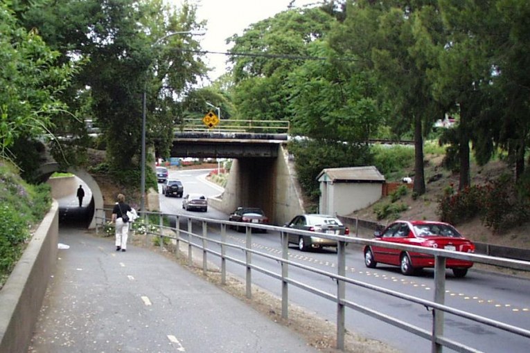

It is 9 AM on a weekday in Davis, and a newcomer driving on Richards Blvd. northbound past Kaiser may be unsuspecting of what they are about to encounter. The roadway looks mostly clear as they head up the overpass that takes them over I-80, but that’s about to change. As they get over the summit of the overpass, the landscape shifts and suddenly the vehicle has to hit the brakes as the traffic is completely stopped.
What they see is a long line of traffic either stopped or moving at a snail’s pace. There is another line of traffic attempting to merge onto Richards from the westbound I-80 Richards Blvd. North exit. There is another line looking to make a left turn from West Olive Drive and another line looking to make a right turn from East Olive Drive.
It is to this existing congestion that the city is potentially looking to add a Hotel Conference Center on the site where Caffé Italia and the University Park Inn reside, and, of course, there is Nishi.
The Housing Element Steering Committee (HESC), when it studied this issue starting in 2007, recognized the problems of circulation on the Nishi site and the impacted conditions of Richards Blvd., and recommended, first, a UC Davis-only access followed by a dual access consideration.
But when the city’s plans for an EIR came out, it turned out that the UC Davis-only option is off the table, while even a dual option is uncertain. The city is studying as equal weight alternatives the dual option as well as a new possibility – an Olive Drive-only access option.
Bob Segar, assistant vice chancellor for campus planning, spoke at last week’s council meeting and the campus would not even commit to the dual option at that time.
“For the roadway plan to be fully analyzed, it has to be in the context of our future growth as well as potential future growth at Nishi. Those scenarios would get fully developed this spring.”
“At least for implementation of it, it would require an approval and I think it does require being part of the growth plan,” he said.
Mr. Segar said they run these processes locally in terms of the long range development plan and environmental impact reports, but ultimately the Regents are the agency that makes the call. The long range development plan is the closest thing that the university has to a city general plan, he explained.
Mayor Pro Tem Robb Davis said he was mainly concerned about the undercrossing, explaining, “In my view that connectivity piece is a huge piece of this from our side.”
What Bob Segar told the council implies that we may soon be locked into this approach. He explained to the council at the meeting, “We did a very high level first pass of the traffic implications of the connection/no connection but really now that there’s a preferred alternative, that can go the next level of detail of traffic analysis as you prepare for the environmental impact report.”
The question that I tried to raise numerous times last week is how we got from the HESC recommending either a UC Davis-only option, or a dual option as the less preferred alternative, to a situation where the latter is best case scenario?
The Vanguard got no official response from City of Davis Community Development Director Mike Webb. However, the Vanguard has learned that UC Davis is opposed to such an option, and therefore, at this point, it is off the table.
However, last February, Prakash Pinto in a presentation characterized the University-Downtown Gateway District as a “collaboration between city, county, university and property owners.” Mr. Pinto talked about how this process, which looks to develop not only 45 acres on Nishi, but 42 acres on Solano Park, creates an integrated land use map between the city and university.
Mr. Pinto talked about the need to “foster partnerships” and called it “a regional project.” He stressed “the continued shared integration of City and UC Davis economic development strategies.”
Mr. Pinto continued, “The university and the city can really move together toward a unified goal of how companies and jobs and housing can actually be placed on this site.”
He listed the goals as strengthening campus and community connections, creating a new gateway to Davis as well creating a district that has a balance of residential and employment which meets the growing needs of the university and the city.
Nishi provides the university with key amenities – housing and innovation space which can serve as incubator sites for university-related research, and private venture spinoffs of that university research.
UC Davis stands to benefit greatly from this development. It has a need for additional student housing – the Vanguard has actually suggested looking at greater density on the site. The university is expanding its research push and wants to become a center for research and innovation in the 21st century and Nishi, while a small piece of that puzzle, is key land next to the university.
At the same time, there are challenges with the site, in terms of circulation and access. UC Davis has the ability to alleviate some of those concerns by helping with circulation issues.
However, UC Davis has a greater responsibility than that. The traffic going through the Richards underpass – 85 to 90 percent of that, during peak hours, is not headed to the Davis downtown. Instead, most of that traffic is turning left onto 1st Street and entering the university at A Street, or is turning right onto B Street, then heading north and entering the campus on Russell Blvd. and parking in the parking garage on the north side of campus.
Therefore, the largest impact on Richards Blvd. is already the university.
Can we improve Richards Blvd.? Fifteen to 20 years ago, the city voters turned down the option to widen the Richards underpass. Part of the problem there is that, while the traffic flow through the underpass is a problem, the downtown streets are single-lane and we likely would have shifted the choke point from the underpass to downtown streets.
The city is looking at the Gateway project and potential arch as one plank of improving traffic flow. The city has recently applied for a grant to improve the freeway interchange. But that is still years off, and most likely will not deal with the overall congestion problem.
Therefore, from our perspective, the university benefits, and is seeking to further benefit, from an economic development agreement with the city. The university greatly contributes to the traffic flow problems through Richards and if they want to add to that traffic – as a project at Nishi undoubtedly will – they need to take the lead on finding remedies. That includes traffic circulation solutions, from finding access to Nishi through campus as well as finding ways to reroute traffic that goes through Richards to campus from the east and the north sides of campus.
Nishi represents a great opportunity for both the city and UC Davis. But circulation issues are big, and are only going to get bigger. UC Davis needs to be a partner in the solution. We have presented some innovative ideas and there are probably more that can be developed – but we have to be willing to have this discussion and find out what UC Davis is willing to do, to do their part in this.
—David M. Greenwald reporting


Perhaps Segar and/or UCD can explain why after nearly 5 years of knowing Solano Park is going away, AND knowing that Nishi with similar land uses would logically need additional grade-separated crossings into UCD, AND agreeing to study the concept, NOW say that they need time to review and study it. As it stands, if UCD is not ready to come to the plate, Nishi should be put on such a back burner that no heat be used.
Point well taken. IMO an Olive Drive only alternative for Nishi is a nonstarter as far as Measure R is concerned.
very astute observation and one that has been bothering me for the last two weeks as this discussion has been revived. ucd often blames davis for the slow pace – and rightly so at times – but why is ucd suddenly getting cold feet here. part of the missing piece is solano park and the blow back from the graduate students and katehi’s fear of a reprisal of student protests.
Pretty much agree with the article. The main transportation feature that I gleaned from last year’s meetings on Nishi was the through traffic from Richards/Olive to UCD, avoiding 1st Street. Without that, it’s more traffic, all going to Olive/Richards from Nishi without the ability to bypass U traffic. At that point, minimizing the auto footprint for the site becomes more critical, and the land use proposed may need to be re-considered and re-balanced. I hope the U with come through on the need for cooperating on a tunnel from Nishi to U.
right on. although i hadn’t heard that the ucd to olive drive connection would become critical – it does make a lot of sense – if richards were re-engineered to handle the throughput
DP, I’ve always felt that the problems of Richards are not caused so much by Richards, but rather by how First St and E Street accommodate the traffic coming out of the tunnel. The complexity of the traffic light at First and E and Richards really impedes the throughput capacity coming out of the tunnel.
So how would you change the throughput on First and E to make improvements?
Good question. The traffic light at First and E is as complex as it is because of the high number of pedestrians that cross First Street. Part of the logic behind the Richards Gateway design proposed by Davis Downtown (and others) in 2014 was to minimize the pedestrian crossings at First and E. I liked that idea, and would probably look to incorporate most of its features, which included the construction of a second bicycle/pedestrian tunnel just to the east of the current Richards automobile tunnel.
Thinking outside the box, I would eliminate all pedestrian/bicycle crossing of First Street at E, rerouting it to the much simpler light at First and D Street. The north end of the second tunnel would swerve westward and go under the automobile lanes of Richards just to the south of the traffic light, and then merge with the existing tunnel entrance path that arcs until it is parallel to First Street. That combined sub-ground-level pathway serving both tunnels would gradually rise so that it reaches street level just before the traffic light at First and E Streets in front of the current Bath and Body Works store. The retaining wall along the south edge of that sub-ground-level pathway would be topped by a wrought iron fence similar in style to the current wrought iron fence that encompasses the Arboretum Garden just to the west of Whole Foods. That fence would prevent pedestrians and bikers from accidentally falling into the sub-ground-level pathway, and together the fence and the sub-ground-level pathway would prevent pedestrians from crossing First Street at E Street.
The E Street traffic light and the D Street traffic light would be collectively set up so that the left turn off of westbound E Street onto southbound Richards would be synchronized with the green light at D Street allowing pedestrians and bicycles to cross First Street. The First and D traffic light would have a green for through traffic on First Street as its default and only change to a green for D Street if the pedestrian crossing button is activated or if a D Street car is electronically sensed waiting to cross First. With a (more or less) permanent green on First Street at Second, the flow of cars out of the automobile tunnel looking to head toward the University or north on B Street will be much more free flowing. The light at First and E will have three phases, (A) the aformentioned protected left from westbound First onto southbound Richards (which would also support thru traffic on westbound First Street), (B) the protected left from northbound Richards onto westbound First (which would also support thru traffic onto northbound E Street), and (C) the multi-directional green for southbound E Street onto southbound Richards or eastbound First Street. The protected pocket from northbound Richards onto eastbound First Street would continue to operate as it does. Because no pedestrian crosswalks would exist at First and E, the traffic would flow much more smoothly than it does currently.
Even an experienced traffic engineer would have difficulty solving the traffic issue without modeling the traffic flow. The problem with traffic is you really do need to know the expected flow from each projected source (such as the conference center), as traffic simply reaches critical mass (gridlock), and it’s very hard to predict that threshold without modeling where it occurs. We can speculate what might work, but ultimately a best-scenario from an experienced modeler has to be put forward and then tested with expected future traffic volumes.
“I’ve always felt that the problems of Richards are not caused so much by Richards, but rather by how First St and E Street accommodate the traffic coming out of the tunnel. The complexity of the traffic light at First and E and Richards really impedes the throughput capacity coming out of the tunnel.”
This has been studied many times. The problem is the corridor, and any improvement is NOT dependent on that one intersection (BTW, the intersection is First, E, and Richards). Your “feelings” are yours, but you appear to not understand the problem or possible (feasible) solutions. But allowing Nishi to develop and have access only to Richards/Olive, increase the traffic that would be expected from the hotel/conference center, and expect the design of First/E/Richards to not only mitigate those impacts, but even improve the current situation, is certainly innovative, and should not be disparaged, no matter how clueless it is.
Closing the W-bound leg of First will not solve the problem (and would create others). Closing Richards between Olive and First to motor vehicle traffic would solve the problem, but create so many others I have neither the time nor inclination to expound upon them.
But still, we shouldn’t discount any ‘possible’ (whether feasible or not) idea. That would be “wrong”.
No… at the risk of violating the “be nice” concept (which I support), it is “ill-informed” (previously, ‘stupid’) to think that the UCD TO OLIVE DRIVE CONNECTION IS CRITICAL. A connection(s) to UCD from Nishi IS CRITICAL to make Nishi viable. It is also “ill-informed” to think that Richards AND FIRST can be “re-engineered” to handle the throughput of Nishi, UCD, and the conference center/hotel at Richards/Olive without changes to First, B, I-80 that would (a ta 90% confidence level) ‘handle the throughput’, in a way that would be acceptable enough to the community to get a positive vote from the electorate. But, of course, engineers should be expected to solve that, and turn lead into gold at a very low cost, too.
But, that idea is innovative, ‘out-of-the box’, and should be thoroughly studied and not disparaged by reasonable people.
HP, you may be right, you may even be probably right, but are these your “feelings”?
I understand about intuition about how traffic will flow, and often intuition is correct with some experience in the area. However, there is some validity to the idea of a through Olive-UCD-via-Nishi, enough that it should be modeled for feasibility. Not that models are perfect either, far from it! Not that they can’t be manipulated if the one calling the shots with the modeler is also the one that stands to gain from the direction of the results — that happens, too! However, that can be monitored through proper quality control.
This is one complex situation, and without traffic modeling, these discussions are speculative.
Alan, some people would say that “speculative” is what the commenters on the Vanguard do best.
MW, some people would say your statement would be accurate with the very last word removed.
I’ll stick with the original wording Alan.
Alan… “feelings” based on a review of all the modelling and traffic studies done on that corridor (subject to City review) since shortly before the development of Davis Commons until very recently. I have not seen studies (if any) for the currently proposed conference center. Have seen the studies for Gateway/Nishi Specific Plan, the previous Nishi project and the proposed widening of Richards “tunnel”. And the traffic studies for various devlopments along Olive (Inn’ Out & Lexington (?) Apartments). Oh, and besides “feelings”, professional judgement/experience, but as I am not omniscient, I guess it is “informed feelings”.
HP: can’t argue with your informed credentials. Well played.
I recall that during presentation of the In-N-Out Burger plan to the City Council, the Olive/Richards traffic situation led staff to referred to it as “In Burger.”
hpierce wrote:
> And the traffic studies for various devlopments along Olive (Inn’ Out & Lexington (?)
Any idea if there have been any traffic studies for this big new apartment project on Olive?
https://my.rcm1.com/handler/brochure.aspx?pv=lRAY2w4kA1tF2331IXExgQbRsCNelijf8wBAtP_jyQkwDgQhZzIlesLJ4qB2_MAi
South of Davis… the citation you used is a marketing tool for what I believe is/was the Callori property. Unless something has recently transpired, the “ad” is somewhat misleading as saying its “zoned” for MF, and probably very misleading to say that it is “greenlighted”. Don’t have a copy of the Gateway/Nishi Specific Plan handy, but as I recall, the land use is not inconsistent with that plan, for that site. The only study governing the land use for that site would have been the Gateway/Nishi Specific Plan EIR.
That study would be more than a bit “worthless” for any proposal today, given subsequent approvals in the area since then. Don’t know what assumptions are to be used in the traffic study for the conference center, which, as I said,I have not seen. Not even sure if it has been completed.
Please see http://www.davisenterprise.com/forum/opinion-columns/the-potential-for-nishi-great-location-horrible-access/ for an excellent article concerning this matter by Professor Emeritus Robert Thayer, a retired professional land planner and a long-term resident of Davis. This article was published as an Op-Ed piece (p. B5) in the August 17, 2014 (Sunday) issue of the Davis Enterprise.
Very nice article, and great points by the Professor.
Ya know, if they wanted to move the In-N-Out and Dutch Bros to Nishi, force them, then build a new off and on ramp from I80, the profits and traffic would make Davis look like a ghost town!!
But seriously folks, You cannot Grow things by Limiting access to them. The Richards problem has always been there, and maybe they have studied it enough to document, as some of you say, the traffic goes to UCD. If so, cut off access to UCD at 1st and B and all those people access campus through I80 or 113. They already do this on University and Third St. Going THROUGH Downtown is such a waste of energy but some drivers have no imagination. Putting up some signs might help adjust behavior?
They also claim in another thread like this that 400 people bike across I80. I am sure more than that use cars, which means these are students from the myriad apartments on the South Side. Address that, and you help the situation?
Nishi development has to realize putting more people on that intersection is useless to the image and viability of a growing Innovation Center by using a one hundred year old tunnel into town. Davis is like that in a lot of places, you drive through a lot of rough places to see the jewels.
At some point, the love of the automobile may have to be reassessed.
This area is terrible for all modes of transportation. Walking, cycling, driving. Yet all I’m hearing so far is hand-wringing on how we make it better for automobiles. Some comments even mention restricting pedestrian access to facilitate that. Maybe instead of searching for that elusive, expensive bandaid, we should look more critically at what is causing the wound?
“Some comments even mention restricting pedestrian access “
The restriction of pedestrian access should come as no surprise. Restriction of pedestrian access has been seen as the solution to another problem recently. When I first moved to J Street three years ago, I could walk directly from my house in Old East Davis across the tracks into South Davis cutting about 10 minutes off my preferred means of going to work, namely walking. Then the fence was built along the south side of the east west railroad line in response to deaths on the tracks.
So the choice was made to limit the accessibility of two neighborhoods by the pedestrian route. Did this decision keep people off the tracks. Absolutely not. Last weekend, while walking to downtown, there were 5 teenagers sitting on, running along, playing on the tracks. The entire north side of the tracks is completely open. While the issues are different, the solution is the same. In order to decongest, or protect, or provide better car access, or do whatever is seen as needed, the solution has been to limit pedestrian access often without mitigation.
Having lived in 13 different towns and cities in my life, I can attest that Davis is by far the most accommodating to pedestrians and bicycles. But that does not mean that we are even close to equal choice. Our entire transportation system has been designed around the needs and convenience of those choosing to use their cars. When I read questions like “Shouldn’t there be choice ?”, my answer is a resounding “yes”. There should be equal choice. And I would invite you to come walk with me around our community and learn to what extent my choice to walk is inconvenienced and in some cases, nearly eliminated by others choice to drive.
Every neighborhood in Davis is open to automobiles. The question I would pose is why could there not be even one “car limited” neighborhood in all of Davis ? Would that not also be a “choice” ?
“Every neighborhood in Davis is open to automobiles.”
And every neighborhood in Davis that I know of is open to pedestrians and bikes, especially because both pedestrians and bikes can use the roads equally with cars by law!
Anon
A personal invitation. Come and walk with me. Then tell me that my access on foot is equal to that of cars.
Tia – I will see your foot, and raise you a bike.
Welcome to the world modernization and better and faster ways of getting around with the use of automobiles. It’s called progress. There will always be those who fight innovation and try to stick to their old ways of doing things. We didn’t use to phones either, should we go back to the telegraph?
Thanks for the welcome. But my OLD way of getting around was by car. The automobile is not “innovation” today. That was well over 100 years ago. Now we just pretend that the automobile is a given, and we try to work around them as best we can. Thus this whole discussion of what to do with more of them.
This car “progress” is responsible for over 30,000 deaths and 2.5 million injuries per year in the US. That brown ring we see around the Sacramento Valley on still days? Another sign of automobile progress. The sedentary lifestyle and exposure to pollution and danger that our automobiles represent requires progress in the medical field just to keep us healthy enough to keep driving to the doctor.
Clearly we all enjoy and benefit from many forms of progress. Having the easy choice to use a 3-6,000 pound, fast, polluting, long-distance vehicle to move an able-bodied person a few thousand feet at a time is not the sort of progress I’m proud of.
I’d like my town to prioritize people. Not cars.
BP
“It’s called progress”
I also value progress. I consider the car as we currently use it an “old way of doing things”. I believe that it is now time to consider whether or not the private automobile is the best that we can do, or whether progress might not also lead us to a transportation path that does not necessitate the environmental destruction, personal poor health, sedentary lifestyles, and dangers to bicyclists and pedestrians that now are entailed by our overwhelming catering to the individual automobile as the default means of transportation.
Like it’s being stated on here, it’s a matter of “options”. You choose to walk or maybe bike, others choose to drive their auto or maybe do all three at different times, but want the option of using their car. Nobody is trying to deny you your options.
BP, first, there is no critical mass of people advocating for bikes allowed and not cars. As it is being discussed, options are being preserved for all … with the different options having different rental costs. Second, it isn’t bikers alone who are advocating for incentives to reduce the amount of surface area devoted to parking cars at Nishi. Mark West, myself and numerous others have criticized the currently proposed Nishi design for too little density. The biggest impediment to increasing the density of people using the site for work and/or their residence is is the amount of surface area devoted to parking cars at Nishi.
Currently, I believe it costs $9.00 per day to park in the UCD lot across from the Mondavi … $9 x 30 days = $270 per month. Setting the rental cost of a parking space on the Nishi-Gateway property at a value equal to the adjacent available parking at Mondavi would seem to be a reasonable market-based approach. That way a person who wants to rent a unit there will have the option of simply paying a rental fee for the housing unit, or paying that rental fee plus $270 per month for each parking space they desire. Similarly, the for-sale units would be sold at a dollar amount that covers the housing only. If the unit buyer desires a parking space they wold have the option of renting one for the same $270 per month rental fee. If UCD raises the parking rate at the lot across from Mondavi, then the rental rates for the parking spaces at Nishi-Gateway would go up in lock step with the Mondavi Lot rates.
With Nishi-Gateway as close as it is to Amtrak, when students want to go home over the holidays, the ones who live along the train routes would have either (A) the train option, (B) car pooling options, or (C) the Zip Car rental option.
Options, options everywhere …
I liked your idea about the tunnel but taking it to B Street might be better on all intersections. Just charging for parking, like UCD does, is nothing more than making it “paying to work at your job”.
Like any tax that is a “fee”, it is taking money you earn. Like a $15 minimum wage, I imagine all the taxes that can now be paid since the people are “earning more”.
Taking a tunnel to Nishi might not be a bad idea either!
I would like to have the option of safe, human-scaled, quiet and pollution-free streets. Would you deny me this option?
BP
“Nobody is trying to deny you your options.”
It may be true that nobody is “trying to deny ” my options, but it is not true that their choices do not limit mine. I make the same invitation to you as I have made to Anon. Come walk with me for a different perspective on how choice is limited by the predominance of the automobile.
When you are done walking with Tia, please come and ride with me.
There is a reason the automobile is the predominant mode of transportation by choice. It gives people the greatest flexibility/independence. Try taking a trip to Lake Tahoe on a bike or walking! Try bringing home 10 bags of groceries on a bike or by walking! To Tia: are you willing to give up your car?
“Try taking a trip to Lake Tahoe on a bike or walking!”
true. but you’ve apparently intentionally limited your options here. you can take a bus, a train, or a zipcar or a rental car to lake tahoe. you don’t need to own a car. i haven’t given up my car but i rarely drive to work. mostly i take the train. i can walk to the train station and walk from the train station to my office in sacramento. i know people who have given up their cars.
“Try bringing home 10 bags of groceries on a bike or by walking! ”
that’s why you don’t do that. what you do is more frequent but smaller trips. a lot of people in davis buy their food meal to meal. it also keeps their food fresh. that said, usually i can get a lot of bags on my bike trailer.
All I see is someone who either bikes everywhere, and their family wonders where they are, wasting hours a day on the ride, OR you travel home, get the kids, travel BACK to the store, get home, eat, then bike to a meeting or school function, then back. When you claim to make more trips, I see a lot of homework time, school functions and community service time curtailed sharply.
One reason for this, is the markets are on the periphery of town, when they used to be in the middles, so they can now be larger. Those are not very bike friendly, are they?
DP please let me know how it is for you and yours. If you are a student with no house or family, then your choices may suit you. I don’t want to go to a grocery every day. I drive places to haul more and save time.
Anon, in this town with its abundance of supermarkets and abundance of local fresh produce, meats and fish, what percentage of Davis shoppers ever bring home 10 bags of groceries? I suspect the number is miniscule. I also suspect that most shoppers do as my wife and I do, we use the supermarket as our pantry. That way we get the freshest possible produce, meat and fish. Nugget Markets does a much better job of storing those items in the freshest possible manner than we could ever do.
Further, I suspect that the plastic bag ban has reduced the number of per shopper bags of groceries further. My anecdotal observation is that the modal number of bags for a Davis shopper is either one or two (one is my first guess) and that shoppers very rarely leave Davis supermarkets with more than four bags.
Personally I go to the grocery store as few times as possible, bringing home at least 6-7 bags of groceries most times. This is going to be true if you have a family of 4 or more.
And yes you can possible take some sort of public transit to Lake Tahoe, but it is not necessarily more “convenient”. But you certainly cannot bike or walk to Lake Tahoe. Even DP admits not having given up his/her car. A car gives one independence – to be able to hop in your car and go where you want when you want, however you want to go, e.g. back scenic roads.
“To Tia: are you willing to give up your car?”
To Anon
As I have posted many times, I am working on doing just that. The move to a neighborhood with a walkability index of over 80 from one of around 20 was just a first step.
Anon
“This is going to be true if you have a family of 4 or more.”
This is going to be true if you choose to organize your life this way. If instead you choose to buy staples in one huge monthly shop, but then buy your fresh goods daily or every other day this is just as efficient depending on how you plan your meals and trips. I know because I did it with family sizes of four to six for variable amounts of time.
“A car gives one independence – to be able to hop in your car and go where you want when you want, however you want to go, e.g. back scenic roads.
Agreed. But what remains unspoken in your post is that your independence limits my independence in being able to safely walk where I would like to. Again, if you do not believe this is true, I will be happy to show you.
Miwok
“their family wonders where they are”
Why would your family not know where you are? When the kids were at home, and now before my partner or I leave work whether on foot or by car, we text the other to inform that we are leaving and check in on whether anything is needed by the other that we should stop and pick up on the way home thus saving wasted time getting home only to find that we need to go back out for some “essential” for the evening meal or for a homework project.
Also, unless you are taking time separately for exercise, the bike or your own feet can be your best means of exercise, not “wasted time”.
“he markets are on the periphery of town, when they used to be in the middle”
The markets are not all on the periphery. Both the Co-op and Whole Foods are in easy walking distance of downtown with both bike access and car parking available.
This is truly about choice and lifestyle preferences. We should be considering the preferences of all. Does anyone doubt that we are currently very heavily tilted in favor of the automobile as our default means of transportation despite its drawbacks and dangers and despite the restrictions it imposes on those who do not favor it ?
You can walk and get safely to anyplace you want to, cars aren’t stopping you unless of course you want to walk down the middle of the street. This is a straw dog argument.