 By David M. Greenwald
Executive Editor
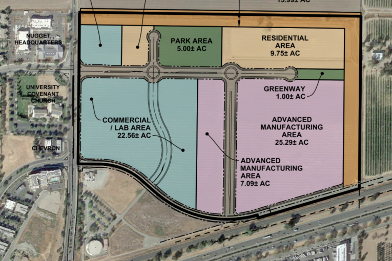
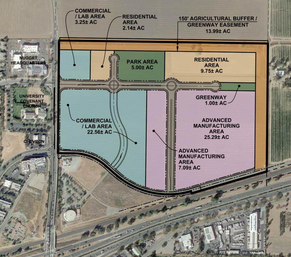
Davis, CA – Just 14 months after the initial project came before the voters and lost, DiSC 2022 returns to the Planning Commission for consideration of the reduced project, now 102 acres with 1.3 million square feet of innovation space and 460 residential  units.
As reported in early December, the city released an Addendum to the EIR. As staff notes, “An Addendum does not have a formal comment period, and that has already occurred as part of the EIR process. However, the city posted the Addendum on December 1, 2021, well in advance of the first public hearing regarding the DiSC 2022 project.
“The DiSC 2022 Addendum concludes that no substantial changes have occurred with respect to circumstances under which the project would be undertaken that would require major revisions of the previous SEIR,” staff writes.
Details of the revised project are presented in the staff report.
Staff notes, “Although the proposal no longer includes the construction of a bike/pedestrian undercrossing under Mace Boulevard the applicant has committed to 1) to prepare a study to determine the most appropriate design for the intersection of Alhambra Drive and Mace Boulevard, 2) to construct said intersection improvements, 3) to provide the land for a future bike undercrossing of Mace Boulevard.”
Parking: “The proposed parking ratios for the overall project site are less than the current requirements under the Davis Municipal Code because there is a plan for shared parking arrangements as the project is built out over time.”
 Floor Area Ratio: “With the reduction in required parking, the proposed project is expected to reach a minimum FAR of 0.7 at full buildout.”
The project will exceed affordable housing requirements with 61 units required, but 85 units proposed by DiSC 2022.
“The Developer is committed to providing, through those means afforded in the Ordinance, for 85 affordable housing units, eighteen percent of the overall housing units. The commitment to 85 units exceeds the Project’s obligation under the Ordinance,” staff writes.
Further, “Developer commits to constructing at least 74 of its affordable units onsite. The onsite affordable housing units will include 60 affordable rental units and 14 for-sale housing units.
“For the remainder of the affordable housing required of DISC 2022, which shall be no less than an additional 11 units,” staff writes noting that this obligation “excludes the payment of in-lieu fees and could include – onsite construction, acquisition of permanent affordability restrictions on existing housing units within the City, provision of a land dedication site, project individualized program or an alternative manner.”
When DISC was proposed in 2020, it was controversially designed with 6.8 acres of ag buffer on the Mace 25, city-owned property.
However, that is no longer in the works.
“The DiSC 2022 project does not adjoin nor does it include the Mace 25 property. Therefore, the Mace 25 property will remain in the county jurisdiction as an agricultural property,” staff writes.
Based upon the City’s consultant, “EPS’s independent analysis that was reviewed by the Finance and Budget Commission, the DISC project is projected to produce $5.3 million in net positive fiscal benefits to the City of Davis on annual basis at buildout.”
The EPS report also identified “significant economic impact through business-to-business activity and employee spending, indirect and induced benefits, on the local Davis economy and Yolo County overall.”
Staff notes, “The DISC project also presents an opportunity to diversify the local economic base and providing an opportunity for major employers that will need employees that fall into a key Davis demographic that has been on a steady decline over the last decade, the 25-55 demographic.”
At the BTSSC (Bicycling, Transportation and Street Safety Commission) meeting in early December, the commission recommended: “The Project will need to implement a comprehensive set of design features and Transportation Demand Management (TDM) strategies intended to reduce vehicle trips and vehicle miles traveled.”
They recommended, “The desired outcomes of a TDM Plan shall be to reduce greenhouse gas (GHG) emissions and transportation total carbon footprint through a reduction of the Project’s vehicle miles traveled (VMT).”
They add, “A key strategy should be shifting away from single occupancy vehicle (SOV) use by incentivizing a mode shift to walking, bicycling, public transit, private transit, and/or 3+ carpool.
“An additional goal of the TDM program shall be mitigation of daily traffic congestion generated by the project by reducing daily SOV trips by at least 33% compared to the business-as-usual (unmitigated) scenario predictions in the SEIR,” the commission recommended. “In other words, at full buildout the project must generate fewer than 12,000 motor vehicle trips per day (compared to the 24,000 trips predicted in the SEIR).
“This reduction requirement is to be applied incrementally at each phase of the Project. If daily SOV trips for each phase are not 33% lower than the business-as-usual (unmitigated) projections in the SEIR, then construction of the next phase shall not be permitted.”


I don’t quite understand this. Maybe I’m reading it wrong but is the mitigation based on the original project’s 24,000 trips per day when the size of the development is now being cut in half? Why would that figure be used? Am I missing something here?
I don’t understand that either Keith.
So are they trying to reduce by 33% the 12,000 vehicle trips per day projections of the downscaled project? Or is it based on the original 24,000 daily trips of the initial project which makes no sense to me?
Maybe David can clarify?
It’s a good question and I don’t know either. Perhaps they were recommending this before they had the revised numbers. Starts on page 79 of the staff report, section called, “COMPARISON OF COMMISSION RECOMMENDATIONS TO THE PLANNING COMMISSION AND CITY COUNCIL”
This is the language: “NRC 36E An additional goal of the TDM program shall be mitigation of daily traffic congestion generated by the project by reducing daily SOV trips by at least 33% compared to the business-as-usual (unmitigated) scenario predictions in the SEIR. In other words, at full buildout the project must generate fewer than 16,000 SOV trips per day (compared to the 24,000 trips predicted in the SEIR). This reduction requirement is to be applied incrementally at each phase of the Project. If daily SOV trips for each phase are not 33% lower than the business-as-usual (unmitigated) projections in the SEIR, then construction of the next phase shall not be permitted.”
This recommended baseline feature was rejected by the developer as well as the recommendations that the Master Owners Ass of the project master-lease 50% of the housing units to ensure occupants are really employees which the devleoper touts is the whole reason for housing on site (i.e if 60% of the housing units are occupied by employees of the projects, only then is it the environemntally preferable alternative compared to an all commercial development which is certainly the economically preferable option from the City’s perspective). Plus the developer has refused to mandate paid parking on the commercial side of the project saying it is “infeasible” even though almost the entire UCD campus and downtown Sac has paid parking.
In other words, the developer is refusing to incorporate these 3 things into either the Baseline Features or Development Agreement which are the 3 most important things they can do to reduce mobile GHG emissions. Instead, they say with great fanfare (que the trumpets blaring ) that it will develop a really, really, really good Transportation Demand Management Plan that will solve all of our traffic congestion and GHG problems (trust them on this) but refuse to commit to anything specific in that hypothetical plan to guarantee traffic and GHG reductions. What a farce!
It’s appreciated that the BTSSC has recommended some common sense initiatives, but none of it will work, even if the developer agreed.
The location is simply too far from the rest of Davis and the rest of the… world…. and driving is simply too easy, except for the small part of the day when there’s congestion.
A small number of people will arrive by bike from nearby, immediately to the west. It’s problematic further west as the infrastructure is simply indirect, slow and in some cases not as safe as it should be (should be, based on our City’s chronically-abused city symbol!). It’s nearly impossible to the south as there’s no plan for a safe crossing of 80 on or next to Mace.
Perhaps a very small number will arrive by public transportation, including shuttles… but these systems cannot compete with travel by motor vehicle.
I live just east of Mace on Cowell. There’s almost cycling or public transport use from here for anyone who has the choice.
Driving is TOO easy, can we grok this? It’s minutes by the I-80 to anywhere from this part of town. It’s sprawl, it’s silly. It’s destructive. The developer’s soft approaches like TDM will have limited affect, if that.
The BTSSC should have rejected this project, flat out*. There is no way to save DISC II to make it in any way sustainable. This example of slavery – to the car – cannot be reformed, just like any form of slavery. It has to be banned.
*When I was on the BTSSC during DISC I, I abstained on the vote for the recommendations which formed the template for the current ones.