

By Tim Keller
This past June, former mayor Robb Davis published a piece in the Vanguard entitled “Densifying Davis – A Four-Part Strategy.” which detailed four directions the city should pursue in order to help solve our housing crisis, one of which was the concept to amend Measure J/R/D.
As he stated:
There are, presumably, many ways to amend Measure D. A straightforward way to do it would involve two critical components: defining minimum project development standards that would exempt projects from a citizen’s vote and creating an urban limit line.
I thought this was an intriguing idea but I was skeptical. Could an urban limit line approach actually work? Or would it be just optics?
Congress for example has a “debt ceiling” that they keep raising.. (Meaning it’s not a “ceiling” at all.) Would an urban limit line be the same thing? Or could it be an actual permanent limit line that wouldn’t just get moved in the future?
Like many in our city, I’m not against growth per-se, but I really do not want to see “sprawl”.
Having grown up in Los Angeles, one of the things I like the most about living in Davis is the fact that my daily routine doesn’t involve several hours in the car, and I know that this is a value that many others in our town share.
So I decided to dig into the concept a little to see if it was realistic, and that research sent me down a rabbit hole that ended up spawning 5 separate articles in the  Vanguard last spring..
What I found was, yes, the urban limit line is indeed a viable concept – but only if it is implemented as part of a comprehensive strategy. That strategy was detailed in my summary article which can be found here.
The short version of those conclusions is this:
- Densifying our city is a better option than building outward for numerous reasons,
- That said, densification takes a lot of time and can be traumatic if done too aggressively.
- We have RHNA requirements for growth that are in excess of what we can do via infill and densification alone, so the peripheral properties need serve as a safety relief valve in the short term
- If we limit our peripheral building to a relatively small area, and build it at a medium density found acceptable in many other California cities, then we have 30+ years of capacity for housing within that limit line.
- During that 30 years, we can come up with a comprehensive plan for further densifying our core and arterial areas into the future. With population growth rates declining, we then have no basis for believing that we would need to move the urban limit line in the future.
On top of this analysis I also developed a plan for applying modern urban design priorities onto these peripheral neighborhoods: specifically the concept of a transit-oriented development (TOD)
The TOD concept is a recognition of the fact that the “suburban” model of city planning has universally failed. Low density single family homes require cars, and there is simply NO way we can keep up with car infrastructure: You can never make roads wide enough to prevent traffic congestion, and making enough parking for everybody means spacing all of our stores out with parking lots in between. Seminal works like “The high cost of free parking” by Donald Shoup are great places to start if you aren’t clear on this point already. You simply can’t have a nice, robust, walkable downtown like we see in Davis AND have ample parking. It can’t be done, and urban planners have been telling us this for decades now.
To me, given that there is consensus that we need to densify our city, it also didn’t make sense that we should be building these new neighborhoods at low density also, while we then made plans for densification of arterial areas elsewhere. That seemed insane to me.
After all, the properties being proposed, while they are at the current “edge” of town, exist along a major arterial road, Mace Boulevard. Not coincidentally this is exactly why these properties are the most logical for development. There is NO reason why we should be thinking that these projects should be low-density and somehow separate from our desire for densification in other areas of the city.
And so my addition to Robb Davis’s concept was the addition of a density map along with a dedicated transit line that runs through the artery of these new neighborhoods, creating a medium density neighborhood served by a co-designed transitway that embraces modern design principles that are focused on sustainability.
After publishing this work, I wanted to see if it passed muster: Over the summer, I discussed this plan and the attending issues with a wide variety of members of the community.
That list of people included urban planners, a transit planner, people with experience on city planning commissions, experts on sustainability, and of course, a number of rank-and file Davis residents who have varying levels of interest in topics like this. Notably, I have also discussed this concept with representatives of the two proposed developments furthest along ( Village Farms and Shriners).
For me, this process was “due diligence”: I was looking for criticism of the plan, looking for alternate ideas, weak spots, bad underlying assumptions, and sanity checks.
Today I want to share how my proposed concept for a Measure J/R/D modification has changed over the course of those discussions, and I would like to propose at this point that other members of the community, including our council and planning commission now take up this plan as a viable option for our city, and help evolve it even further.
The proposed Measure J Amendment:
A property that lies inside the geographic boundary indicated in Exhibit 1 may be annexed into the city for development by a majority vote of the city council if the proposed project is found by the planning commission and the City Council to have met ALL of the following four requirements:
- The proposed development plan is materially compliant with the most recent city masterplan adopted by the voters for that area.
- The initial plan is indicated in Exhibit 2,
- This plan can be updated by majority vote of the citizens during even-year November elections.
- The overall gross density of the project is at least of 20 du / acre for designated residential areas.
- 7% of the project gross acreage is dedicated to the city for the development of affordable housing.
- All buildings are constructed to energy efficiency, green building and other sustainability standards set by the city.
In the above, the elements that are underlined are variables where I think our community has to have some focused discussion in the coming months. I have included the current placeholder assumptions that I’m working with above, but that doesn’t mean that these are necessarily the final values.
The limit line map:
There has been discussion as to whether the areas further to the west of Sutter hospital should be included, or whether the proposed development to the south of El Macero should be included. I am leaning towards NOT including those areas of the city in the limit line for two reasons:
- There is no obvious way to link those areas to our downtown and to the university via transit, and building with transit specifically in mind is absolutely central to sustainable city planning as discussed above.
- If we build with the appropriate density levels. We have no need to develop those other areas anyway. (This is discussed further below)
So the proposed limit line would make the Village farms property subject to the sustainable development exemption along with the rest of the mace curve, all the way down to the former DiSC site. This is 932 new acres which (as will be discussed later), gives us room for 40 years worth of housing growth if we build according to this plan.

1) The Neighborhood Conceptual Plan
The map shown here is a slightly simplified version of the original map i drew earlier this year

I am not trying to “plan” any of these neighborhoods with this map per-se but instead to make a particular request:
Look at where the orange and red areas are: this is intended to represent medium density housing and mixed use commercial / residential zoning respectively. See the blue line? That is a dedicated transitway: A bicycle superhighway that will also have a lane for busses,( but not cars.) At the planned density of 20 units per acre, there will eventually be enough population along that transitway for the buses to be replaced by a light rail system. (The density where light rail starts to pencil out is 15 units / acre.)
There is quite a lot to say about housing density and transit and how the interplay of the two are at the very core of modern sustainable city design, but for the sake of keeping this particular article short, I am going to reserve that conversation for later, for now, I am presenting this map to make one specific point: Transit-oriented city design is a realistic option for Davis, even on the “periphery” like this.
These new peripheral neighborhoods once built will be creating their own new arterial corridor, and we very much should expect to have the new “Mace Corridor” be as dense as we are thinking for other main streets in our city, like Covell, Anderson and Russell. Village farms for its part lies at the intersection of two of our most important arterial corridors. To me, this makes abundant sense, but if you look at the proposals for these properties as put forward by the developers, it is clear they aren’t thinking about the neighborhoods in context of the rest of the city, or with a mind toward traffic vs transit, or how their development impacts our ability to grow in the future, and THAT, really, is what I object to the most.
Returning to the topic of the proposed language of the amendment: You will notice that there is now language that talks about how the neighborhood general plan is updated. This is in the hopes that the city does eventually get around to creating a new city-wide general plan, or at least can dedicate themselves to creating a more detailed specific plan for these neighborhoods than what we can produce in the short term.
Now again, ANY plan for these neighborhoods is going to be better than NO plan, and we really have no ability to wait for better planning before we act. If we do not do this and Measure J/R/D ultimately fails, then we will have lost any ability to do ANY master planning whatsoever: We will be at the whim of the developers who will dictate what THEY want to build. That is not a position most of us want to be in.
You will also notice that the suggested mechanism for updating the plan still requires a popular vote in a November election. I added this because several people expressed cynicism over a plan update process that was entirely up to the council. What would prevent developers from being able to pressure the council into gutting the plan outright?
At the same time, the plan does need to be relatively stable and predictable, so that developers can plan accordingly. So having a set period for updates, coincident with general elections (which are much higher turnout), seems to be the right balance. It keeps the development decisions “in the people’s hands” where it is safer from undue developer influence, and gives it some stability so that developers can plan their proposals accordingly.
Again my map here should be seen as a jumping off-point: a proof-of-concept prototype, not a final product. I would like the planning commission, or perhaps even other better-qualified citizen planners to take their own stabs at laying out these neighborhoods. Perhaps a design showcase / charette can produce the ideas we are looking for? The time to start those discussions is now.
2) The Density Standard
Density in housing is absolutely essential if we want to even pretend to take our climate crisis seriously. This is because our individual carbon footprints are almost entirely dictated by the density of our housing, and the way we get to work.
This topic deserves its own article, especially since it seems that when people hear the word “density” they automatically assume you are talking about high density, like New York or Singapore.
We are NOT talking about high-density in Davis.
What we ARE talking about is medium density housing, also known as “missing middle” housing: Condos, Apartments & Townhomes, If you have seen the south end of the cannery, that is pretty much what we are talking about.
The following graphic from calcities.org is helpful in visualizing the density we are talking about.
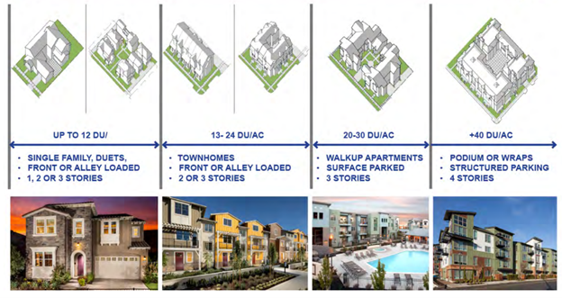 At the moment, my proposal calls for an average density specification of 20 dwelling units per acre. That’s about the current overall density of Berkeley. If you look at the above graphic, you should understand immediately that I am not talking about a crazy level of density here. In fact, we have many housing developments in this town with these moderate levels of density already – we just don’t have nearly enough of them.
3) The affordable housing specification
When it comes to affordable housing, we are used to talking in terms of “percent affordable units”. A metric of “15% affordable” is not uncommon in relation to housing projects before the city. But in my conversations with community members since the publication of my first series, it has become apparent that this is probably not the right way to be thinking.
Specifically this is because we are also asking developers to build “missing middle” housing: Apartments, townhomes and condos, which are more affordable by nature because they are denser and make better use of the land.
But that change in density affects the math of land dedication in an adverse way: A 5% land dedication in a normal single-family development ends up being 20% affordable in terms of dwelling units, when the single family development is at 8 units / acre and the affordable section is denser at 40 units / acre. That math gets you 20% affordable.
But if the developer also is persuaded to build more “missing middle” housing at an average of 20 units / acre for the market-rate units, then the same 5% land dedication only ends up as 9.5% affordable in terms of units…. Same number of units, just less by percentage because the developer was ALSO asked to build more market-rate affordable housing.
We really don’t want to dis-incentivize developers from building more market-rate affordable housing. So the solution is to leave the density issues out of the land dedication math: Just focus on the percent of the land in the project being dedicated instead. We are starting here with a request of a 7% Gross land dedication, (That is, 7% of the project site in total.)
If this number is too high or too low, we can discuss that. I would love to see some historical data or some financial analysis on this point brought to bear.
4) Green Building Standards
Creating a carve-out to Measure J/R/D to incentivize the construction of highly sustainable housing would not be complete without the inclusion of green building standards.
The form factor of the buildings themselves are of course the largest “green” benefit in this proposal. Single family homes have more than twice the carbon footprint and three times the water usage compared to multi-family structures, but it is also important to make sure that the buildings themselves are sustainably constructed and energy efficient.
To this end, it was first suggested that we include some requirement for sustainable building practices, such as adopting LEED-Silver as a minimum standard. But it was subsequently pointed out to me that LEED-Silver is functionally equivalent to the California building code anyway, and might be counterproductive. Instead it has been suggested that the city can adopt sustainability standards for buildings, neighborhoods and transportation that have been developed by the Natural Resources Commission for previous developments to ensure that specific features we want are adopted. For example, the City’s building standards are based on the CALGreen Reach codes developed by the state and are the basis for the City’s current residential building code.
Is the limit line concept still viable?
Within the limit line shown here, we have 932 acres developable as housing. If the average density of this housing is 22 units per acre, and the population growth rate is 1% per year, then the simple math is that such a limit line has enough capacity for 40,000 people and will reach capacity after 46 years. (I will expand into the details of this math in a separate article soon)
Of course, the newest population projections have a California growth rate at only half a percent annually, and as mentioned above, our long-term goal is to densify our core and arterial areas city-wide, so these peripheral properties are not the only places where we will be adding population in the next 40 years.
So is this urban limit line enough to accommodate our housing needs for the foreseeable future? Absolutely. But only if we build with sufficient density, especially along the Mace corridor. If we build these peripheral properties at lower density, then we will need a limit line roughly twice the size.
What is next?
I think this concept has come about as far as it can in the hands of someone such as myself. I have refined the idea, bounced it off numerous people, gotten feedback, and have yet to find anything indicating that this isn’t the best option for us to manage our growth as a city.
Measure J/R/D is broken–there is really no denying that anymore–and the perverse incentives that it creates are obvious to everyone who has been tracking the debate around it, yet fixing it is still much much better an option than simply watching its demise.
If this is the path we are going to go, then a wider cross section of our community needs to take this issue up and develop it further. A modification of Measure J/R/D needs to be presented to the voters BEFORE the existing Measure J/R/D projects are voted upon, otherwise there is no point, which means it needs to be on the November 2024 ballot. This is plenty of time to iron out the details presented here, but it means we can’t procrastinate on this either.
City Council members, Planning Commission members, and others members of our community who have interest in these topics: I am placing this ball in YOUR court. I will be transitioning to working with other community leaders who want to see this change happen, and working with you to make sure that this proposal works its way onto the November 2024 ballot in the best form possible


Tim Keller has done a laudable service for the citizens of Davis by crafting a document that tackles most of the housing issues facing Davis today and in the future. I applaud his contribution and the points he brings to the dialogue.
Tim does present his topics as places to start from and invites comments and other opinions. He wishes a dialogue to start and certainly dialogue needs to start and remain civil. As to planning and housing in Davis the various conflicts do not yet seem to find acceptable answers. Without changes the status quo will prevail and we will continue growing without measurable progress on the topics of global warming, housing affordability and racial and low income inclusion.
Staying on the path we are on will mean a city that becomes by per capita population richer and whiter. Is that the future that Davis citizens want?
In making my first contribution to Tim’s request for dialogue I wish to speak to the affordable housing component.
I do agree that setting a % of the gross acreage for affordable housing is a valuable start. What I would like to suggest is that the % of the land chosen included a portion of that % be specified for low and very low income housing that remains affordable over time.
By the nature of the direction that laws are being passed our inability to provide affordable housing for low and very low income households is the most likely to be where the state takes action against Davis.
Again, thank you Tim for kicking this off
Allow me to start there and add more over time,
David J Thompson
My opinions are mine own and are not representative of either Neighborhood Partners, LLC or the Twin Pines Cooperative Foundation
Thank you David,
Given your experience, are there any precedents in terms of past projects where land was dedicated in this way that might give us a starting point for the numbers to use here?
Dear Tim,
We really don’t have valuable examples. Almost every developer has set aside the amount of dedicated land as was required and no more than that. On the other hand land set aside for open space, parks, greenways has always been more than enough.
As I look at it, each acre of land set aside for any purpose other than housing is an acre of lost profitability to the developer.
So why cannot there be a swap of for twelve acres of what is planned to be parks (I think 140 acres in Village Farms) bringing the acres for parks down to 128 acres and now we have twelve acres of land for permanently affordable housing that could create four three acre parcels interspersed within the development (but transit close) to house 90 units each (creates 90 units at 30 dwelling units per acre). So 360 affordable units in total.
The present RHNA numbers are 960 of very low and low income units required and 360 at Village Farms is 37% of the RHNA tota.
Just a small shift of land set aside for affordable units will keep the state away from plannning for us.
David J Thompson
My own thougths not representative of either Neighborhood Partners lLC. or the Twin Pines Cooperative Foundaion
For now I am not taking a position on J/R/D being broken, or not. I am of course – like all mature adults – pondering the elusive General Plan update. I’m mainly going to go on about the transporation in the “Neighborhood Conceptual Plan”, above…
Background is that I am also from L.A. – Canoga Park and Culver City – BUT afterwards lived in SF – mostly in the Mission District – for 12 years, mostly here and here in the East Village for over three years, here and here in Prague around here for eight years and here and here in Berlin for over three years.
* Intermission *
CITIES ARE NOT NOISY, CARS ARE NOISY
* End Intermission *
The units per acre threshold mentioned above that makes light rail pencils out sounds nice in theory, BUT:
* What would be the door-to-door journey time from the end of the line to F and 2nd, and then on to Hutchinson and the Quad?
* Is this based on signal priority?
* Parking is not mentioned at all beyond the likable Shoup stuff — assuming that most or all households have a single vehicle, how competitive will light rail be? Why would a family of four take transit, unless it’s free…
* Will parking Downtown be free? Why would people with free parking at both ends of the hjourney walk a total of ten minutes, wait and then take 15-20 minutes to get to Downtown?
* There is likely little speed advantage on this route for light rail, only capacity – but it’s marginal compared to long, articulated buses – and it may require less personnel. Both buses and light rail can use, for example, renewable energy for recharging en route. Light rail will likely be a nicer ride…
* Oh, more on the likelihood of at least one vehicle per household: Light rail is generally considered to use a dedicated railway, whereas streetcars share (So the system in Sacramento is both, depending on where it is). Can Mace be adjusted to one lane in each direction for all motor vehicles? If emergency vehicles have to use the light rail section, it will have to be paved (unnecessarily ugly for occasional use).
* F St absolutely has no space for a dedicated corridor even if parking is removed on both sides, because of the hoped for “cycle superhighway”. Is the plan for F to be carfree?
* The California Northern operates what, three trains a day on the corridor towards Woodland? Can we do something better with this?
* Cycle superhighway – This is wonky jargon if it’s not really a dedicated corridor where one doesn’t have to stop very much. There’s also a HUGE problem aka the steep Covell over-crossing of the existing railway.
* All this and no stop a few feet away from Capitol Corridor/successor services trains? And why would anyone who lives near the Mace Curve use it to get to Sacramento, for example, when in 20 minutes they could be in the middle of Sacramento?
Back to the places I lived in Europe: The two main places I lived in in Prague had two streetcar lines operating every ten minutes and alternating (so every five minutes) with both lines heading to different parts of the center AND to many, many places en route in BOTH directions, including multiple metro stations, about 19 hours per day; a metro line operating every 3 to 5 min. about 19 hours per day; all night streetcar services running every 30 minutes within a ten minute walk. It was all very affordable with a certain kind of pass, very reliable, etc… and most people using it didn’t have cars. Berlin was roughly similar, with less transit. But lots of places to walk to and then take the streetcar back. 30 sec walk to a bus stop in Berlin that went direct to the main station (20-25 minutes.)
Summary: The only way any of what’s proposed will work is if 1) Parking is expensive Downtown; 2) Almost no one has car parking at the new medium-dense places (and there are no permit loopholes nearby); 3) There’s a much faster and frequent mainline rail service and the bus/streetcar-light rail goes directly to Davis Depot; 4) 5 to 10 min headways at least 18 hours per day; 5) Fare-free! 6) The bike route to Downtown and Campus is direct, with no crossing over one of the biggest hills in Davis, and is actually “super”.
Ultimate Ask: Re-route I-80 to the south and build lots of good stuff in the reclaimed area, almost no cars, hyper-direct local and regional rail access, etc. This is also a reaction to slimy, old school Caltrans’s proposed widening of the freeway: The status quo is a very noisy, rumbling highway. A hoped for victory against this sham keeps the highway at three lanes: That’s not progress.
Post-script: Still almost no one is talking about how Village [sic] Farms [sic] in all (car-powered) variants will turn 102 into a corridor from hell. Are developers planning to fund extra helicopter ambulances, more helipads at Sutter Davis, free memorials en route? Widening will require more than a median due to need for passing and to add protected cycle lanes will just induce more motor vehicle traffic and will require significant land purchases and even eminent domain procedures. It will likely make it more dangerous. Oh… should I bother to press for a virtually carfree-variant to be scoped in the EIR?
Todd,
Lots of great questions, I cant obviously respond to them all, but hopefully I can share a couple of useful generalizations.
One: I have a VERY narrow target for the people I want to build housing for. They are people who work / study here and are already driving here via car.
If we can target those people with housing, then that is housing that actually decreases traffic impacts compared to now because when they move in-town, then not only are we decreasing the total VMTS inbound on the highways, but some fraction of them will be able to commute in-town via bike or transit instead.
This is NOT a small population… the data I un-earthed this spring indicates we have 20k+ inbound commuters everyday. Village farms and shriners combined are proposing to add ~2,000+ housing units… we have QUITE a bit of housing we could build before we were done re-patriating this particular population.
Two: While you cant legally discriminate based on workplace when you dole out housing, we can encourage it by making housing that is designed to work better for local workers than outbound commuters: (ie: building the housing around bike and transit infrastructure instead of car infrastructure.)
For example, a nice stacked-flat condo like you have in the cannery, that only comes with one free parking space, is not going to be that appealing for a working couple who both work out of town.
But for a university staff member who currently lives in woodland or dixon, housing like that would work VERY well because they don’t need a car to get to work… I have proven this personally… I work in town, and we got rid of our second car three years ago now… I get to ride a super fun electric skateboard, and the family shares one car.
The average cost of car ownership in California is over $10k annually. So housing that is close enough, or connected enough, to your place of employment reduces your budget accordingly. Its a backdoor-way to make housing more affordable for local workers, and ONLY for local workers.
Three: When I say transit, I mean Capital-T Transit. AKA “Transit that is easier to use and more convenient than driving.” When I say something like “bike superhighway” i mean a pathway that goes through town in such a way that biking is faster than driving, and equally safe: Seperated from car traffic, well lit, and given priority at intersections. A lot more parking infrasctucture for E-Bikes and cargo bikes needs to be part of that picture. ( I actually believe that E-bikes could easily replace half the cars in this town and we would all be better for it, but that is a separate topic)
Same for the busses and eventual light rail. I have a friend who lives here in Davis who was formerly on the planning commission in Ithaca NY… where they did an experiment increasing bus service to a bus every 10 minutes. By making the bus more convenient, they ended up inducing enough demand for transit that they had to go to a bus every FIVE minutes.
I am confident in saying this: People will take whatever mode of transportation that you make most convenient for them… Which means we need to put bike and transit infrastructure BOTH at a higher priority level than car infrastructure. ( I know im preaching to the choir here btw..).
Regarding this transitway i’m envisioning, the idea is to keep it off the “normal” road as much as possible. (If it can go down the railroad right of way I think that would be great too). and when it IS on the road, like the gap on the south edge of wildhorse, the signaling would change so that the transit never has to stop for a car to get out of the way.
Caveat: I’m aware that Californians aren’t used to thinking this way… “car brain” is a real thing… but the people in this town are smart, and all of this makes inherrent sense once you are exposed to it… I think we can get there.
The real thing that kills this idea is the fact that we have No planning function in this town thanks to measure J… , and to make it worse, single family housing ( car-served housing by definition) is the most profitable housing to produce for developers, so they have neither the ability nor the desire to think about medium density/ transit oriented planning, so if we don’t fix measure J, none of this is possible anyway.