DAVIS, Calif. – The City of Davis has released the long-anticipated Draft Environmental Impact Report for the proposed Willowgrove Project, a major mixed-use development that would add about 1,250 new homes on a 232-acre site north of East Covell Boulevard.
The Draft EIR, prepared by Raney Planning and Management Inc. for the city, marks a key stage in the state-mandated environmental review process and opens a 45-day public comment period running from Nov. 10, 2025, through Jan. 2, 2026.
The release of the document—identified under State Clearinghouse No. 2024070522—invites community review and comment before city leaders consider whether to approve annexation and entitlements for the project.
The Draft EIR, published in accordance with the California Environmental Quality Act, evaluates potential environmental impacts, proposes mitigation measures, and examines project alternatives intended to reduce or avoid significant adverse effects.
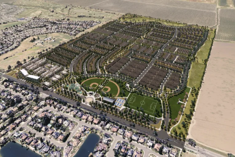
The Willowgrove Project, formerly known as the Shriners Property Project, proposes to transform what is now intensively farmed agricultural land into a master-planned, mixed-use community located outside the northeastern boundary of Davis, just north of East Covell Boulevard and Alhambra Drive. The site, designated Agricultural in the Yolo County General Plan and zoned Agricultural Intensive, lies within unincorporated Yolo County.
The development would consist of a total of 1,250 residential units distributed across approximately 104.7 acres, with a range of low-, medium- and high-density neighborhoods. The plan includes both market-rate and affordable housing and seeks to integrate a mix of housing types, from single-family detached homes to apartments and townhomes.
The community would feature neighborhood retail and commercial spaces, a daycare facility and community gym, extensive open space areas including an 8.7-acre system of neighborhood greenbelts, a community park, a mini park and a network of shared-use trails.
The plan also designates an Urban Agricultural Transition Area along the northern and eastern boundaries, connecting to the existing Wildhorse Agricultural Buffer to the west. The proposal includes on-site and off-site infrastructure improvements such as water, sewer and storm drainage systems, and traffic-calming measures.
Primary vehicle access would come from two intersections along East Covell Boulevard—one at Alhambra Drive, which would be extended into the site, and another new intersection at the southeastern edge of the property.
The internal street network would include local and collector streets organized around the central park area, along with multiple traffic circles and multimodal connections. The proposal emphasizes a multimodal transportation network designed to accommodate walking, bicycling and transit.
Sidewalks and shared-use paths would link the development to existing city trails, including the Wildhorse Agricultural Buffer and the underpass connecting to East Covell Boulevard. The EIR states that the project would add more than three miles of new shared-use trails to the city’s bikeway system.
Because the Willowgrove site lies outside the city limits, the project requires several discretionary approvals. These include a Sphere of Influence Amendment and annexation to bring the 232-acre site into the City of Davis, a General Plan Amendment and pre-zoning to assign appropriate city land use designations and zoning districts, Large Lot and Small Lot Vesting Tentative Maps to subdivide the property, a Final Planned Development and Development Agreement establishing detailed design and implementation standards, and certification of the EIR and adoption of a Mitigation Monitoring and Reporting Plan.
The Yolo Local Agency Formation Commission would ultimately consider the annexation and Sphere of Influence changes, while the City of Davis would act as the lead agency under CEQA. The annexation would also include detachment of the site from the East Davis Fire Protection District, transferring fire service responsibility to the City of Davis Fire Department.
The Draft EIR was prepared as a project-level EIR under CEQA Guidelines section 15161, meaning it provides a full assessment of environmental impacts associated with planning, construction and operation.
The city initially issued a Notice of Preparation in July 2024, opening a 30-day scoping period and holding a public meeting to gather input on the environmental topics to be studied. During that process, the city received 25 written comment letters and five additional written comments submitted at the scoping meeting.
Commenters included state and local agencies, advocacy groups and residents of Davis. Among the agencies providing input were the California Department of Transportation, Central Valley Regional Water Quality Control Board, Department of Toxic Substances Control, Native American Heritage Commission, Federal Emergency Management Agency and the Yolo Habitat Conservancy.
Residents raised concerns about traffic congestion, farmland conversion, water supply, flood risk and the consistency of the project with the city’s climate action goals.
Because the project would convert about 230 acres of farmland to urban use, the EIR finds a significant and unavoidable loss of agricultural land. The site is currently classified as prime farmland under the state’s Farmland Mapping and Monitoring Program and has long been cultivated for row crops.
Mitigation measures include compliance with Yolo LAFCo (Local Agency Formation Commission) policies on agricultural land conversion and establishment of an Urban Agricultural Transition Area, but the loss of farmland remains unavoidable under CEQA criteria. The report concludes that this conversion constitutes an irreversible change, contributing to cumulative regional farmland loss alongside nearby projects such as Village Farms and Palomino Place.
Construction and operation of the project would generate criteria pollutants and greenhouse gas emissions.
The EIR requires best available control measures during construction, such as the use of Tier 4 final engines, dust suppression and limits on idling times. Operationally, the project must implement a Transportation Demand Management program, promote electric vehicle infrastructure and integrate renewable energy consistent with the city’s Climate Action and Adaptation Plan. Even with mitigation, long-term emissions could remain significant and unavoidable, as total greenhouse gas output is projected to exceed local thresholds.
Traffic and transportation impacts represent another major area of concern. The Transportation Impact Study found that development would increase vehicle trips on East Covell Boulevard and nearby intersections.
The EIR calls for the addition of turn lanes, upgraded signals, a second westbound lane on East Covell Boulevard along the project frontage under cumulative conditions and improvements to bicycle and pedestrian facilities.
The project would also contribute its fair share toward regional transportation improvements and prepare a Transportation Demand Management plan to reduce vehicle miles traveled. Despite these measures, cumulative traffic increases, particularly on Covell Boulevard and the Interstate 80 corridor, are expected to remain significant and unavoidable.
The EIR notes that the project will include both market-rate and affordable housing as part of its 1,250 total units. Under city policy, at least 15 percent of units must be affordable in accordance with the Inclusionary Housing Ordinance.
While affordability itself is not an environmental issue under CEQA, the Draft EIR identifies the inclusion of affordable units as a social and policy benefit that advances Davis’s Regional Housing Needs Allocation goals and supports a more inclusive housing mix within the community.
The site’s drainage channel, known as Channel A, contains riparian habitat and serves as a corridor for wildlife movement. The EIR calls for pre-construction biological surveys by qualified specialists, adherence to the Yolo Habitat Conservation Plan/Natural Community Conservation Plan and preservation of riparian setbacks. Mitigation also includes habitat restoration and monitoring requirements to avoid direct impacts on special-status species.
The project area is crossed by a drainage course and lies within the broader Davis Drain watershed. Several agencies raised concerns about downstream flooding and capacity in Channel A. The EIR requires hydrologic analysis for 100-year and 200-year flood events, on-site stormwater detention basins and compliance with city stormwater standards to ensure no net increase in runoff. The report concludes that, with mitigation, hydrology and water quality impacts would be reduced to less-than-significant levels.
Construction activity would temporarily elevate noise levels at nearby sensitive receptors, including homes in the Wildhorse neighborhood and Harper Junior High School. Mitigation includes restricted construction hours, temporary sound barriers and equipment mufflers. Operational noise impacts from increased traffic and community activities would remain below city thresholds with mitigation.
The EIR notes that the Davis Joint Unified School District would experience increased enrollment due to the new housing. The project would be required to pay statutory school impact fees and provide land dedication or in-lieu payments for park and recreational facilities. Fire and police services would be provided by the city following annexation.
The city’s Water Supply Assessment concludes that Davis has adequate water resources under normal, single-dry and multiple-dry year conditions to serve the project, given the city’s surface water and groundwater portfolio. Wastewater would be treated at the city’s wastewater treatment plant, which has sufficient capacity according to technical memoranda appended to the EIR.
The EIR acknowledges cumulative effects when combined with nearby developments such as Village Farms, Palomino Place and On the Curve. Major cumulative concerns include growth-inducing impacts, farmland loss and regional traffic. While mitigation can reduce many individual effects, the conversion of farmland and incremental greenhouse gas emissions remain significant and unavoidable.
The Draft EIR evaluates five alternatives: a no-project alternative retaining current agricultural use; a lower-density option with 937 units eliminating retail and park space; two smaller-footprint designs maintaining 1,250 units; and a higher-density option with up to 1,500 units. The environmentally superior alternative identified in the EIR is a reduced-intensity version that provides fewer units within a smaller footprint, lessening farmland loss and traffic impacts while meeting some of the city’s housing objectives.
The public review period runs from Nov. 10, 2025, to Jan. 2, 2026. During this time, agencies, organizations and individuals can submit written comments on the accuracy and adequacy of the Draft EIR. All feedback will be reviewed by the city, which will prepare written responses and compile a Final EIR.
The Final EIR will include any necessary revisions and a Mitigation Monitoring Program. The City Council must certify the Final EIR before considering project approvals. If it determines that certain significant impacts are unavoidable, the council may adopt a Statement of Overriding Considerations explaining why project benefits outweigh environmental costs.
The city encourages residents, community groups and agencies to review the document carefully, noting that the Willowgrove proposal represents one of the largest potential housing expansions in Davis since the Cannery. The outcome of this process will determine whether the project proceeds to the ballot for voter consideration under Measure J/R/D requirements.
Follow the Vanguard on Social Media – X, Instagram and Facebook. Subscribe the Vanguard News letters. To make a tax-deductible donation, please visit davisvanguard.org/donate or give directly through ActBlue. Your support will ensure that the vital work of the Vanguard continues.

Watch the project get ripped for both adding too much housing and not being dense enough.
It’s going to get ripped (and ultimately lose) because it’s massive in size, paves over farmland, and adds an insane amount of traffic for no reason.
It is in no way, shape, or form a “benefit” for Davis, its residents, and those surrounding it.
Tell that to Eileen
Seems like you’re more in favor of Village Farms, than Willowgrove. Perhaps the same way that the local leader of the Sierra Club might be for some reason.
(Though truth be told, I mistakenly thought this article was referencing Village Farms. Did you write an article “announcing” that EIR – other than the one where you advocated for increased density?)
By the way, why is it that density is being advocated for Village Farms, when the number of units is “fixed”, regardless? (Unless they create a new EIR?)
Your first paragraph is wrong for me. I am for housing, period.
Ron O
Why do you care? And why should we care what you say? You live in Woodland and have no stake in this discussion. Your opinion without any supporting evidence to your claims is meaningless here.
Ron O
Apparently you haven’t been paying attention to the facts that Davis has a 50% price premium compared to neighboring cities indicating that we have excessive housing demand, and that a large number of students transfer in to DJUSD form other towns because it has desirable schools. Our town also is aging so that we are losing the vitality that used to characterize Davis much more. But you wouldn’t notice those things because you live in Woodland.
Sounds like newcomers to the area should seek out Woodland (and are doing exactly that), though I don’t think the difference is quite that much. Also not sure why anyone is even moving to the area, when UCD isn’t hiring more staff.
I’m still wondering if you’ve explained to the local developers that you and the 4 others on your group live in Davis, and therefore have more sway over what they do. (How’s that working out for you?)
Also not sure why there was an article regarding the superintendent living in West Sacramento (when he was still a principal at DJUSD), and why he didn’t therefore seek employment where he actually lived. They don’t have schools in West Sacramento?
Richard: Let’s explore this further.
You say there’s a 50% price differential. Since the cheapest new houses in Woodland are approximately $550K, that means that an equivalent one in Davis would be $825K.
And since Woodland students can (and do) attend DJUSD without paying DJUSD parcel taxes, and Woodland has more “vitality” according to your own criteria, what do you think newcomers (especially families) will primarily choose? Especially since it’s a very easy commute to UCD, without even going through Davis?
Personally, I think a pre-existing house in Davis is a far better deal than a new house in Woodland OR Davis.
But builders sometimes do offer their own financing, which probably appeals to some buyers. (Right up until the time that they receive their first tax/Mello Roos bill, the latter of which older homes don’t always have.)
Sales people always focus on the amount of payment one can afford, rather than the total cost that someone is saddled with for years/decades.
Don’t forget not having an E-W transit/bike/ebike/ped transit corridor connecting to adjacent properties.
Alan M
Good point. That’s a result of having Measure J/R/D which largely precludes joint planning by making developers rivals rather than incentivizing them to act cooperatively with the City planners.
This project appears to be better aligned with City objectives than Village Farms. It has a higher share of Affordable and market-rate affordable housing, belying the claim that Village Farms cannot be altered and still be financially feasible. We’ll see how WG fits as we dig deeper into the EIR.
The park should be placed on the eastern side instead so that the neighborhoods are not cut off from Covell and the southern neighborhoods for pedestrians and cyclists. Being onthe southern end will be a major impediment to transit use which is key part of mitigating traffic impacts. Remember that only 30% of UCD employees who live in town drive to work alone which should be true of others who live and work here.
They’d be driving to Sacramento – where they’d primarily be employed.
Also, I like how you and the 4 others on your group think you can dictate where parks go, and how dense the various proposals are. How’s that working out for you, in regard to Village Farms? Maybe they didn’t understand that you live in Davis? I’d suggest telling them that again, as I’m sure they’ll change their mind once they hear that.
Here’s “why” Measure J, by the way.
There’s almost ALWAYS a disconnect between the people who filter through (survive) the election system, vs. the rest of the populace. (You can see this with other examples, as well – such as Lagoon Valley, California Forever, etc.)
https://www.sfgate.com/centralcalifornia/article/california-city-residents-oppose-mega-development-21164901.php