- Willowgrove releases tentative map for 1,250-unit housing project.
DAVIS, CA – Willowgrove is aiming for a November 2026 Measure J election and has become the first project to release its tentative map prior to a vote of the Davis voters.
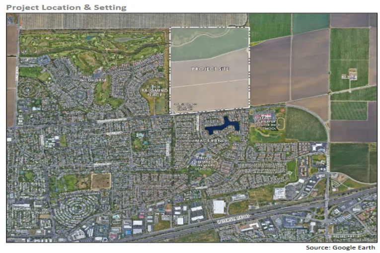
The Willowgrove development proposal advanced another step last week as the City of Davis released its Draft Environmental Impact Report (DEIR) for public circulation and comment about the proposed 232-acre project.
The vesting tentative map filed earlier this year marks a first for Davis: no previous annexation project has completed both small and large-lot tentative maps before securing City Council approval or voter authorization under Measure J/R/D. Project applicants describe the decision as a deliberate effort to provide the public, staff and elected officials with a far more detailed understanding of the proposed community before any final vote.
According to the official Willowgrove project description, “Willowgrove is the first annexation project in Davis that has prepared small and large lot tentative subdivision maps prior to City and voter approval, which allows the City and public to evaluate and understand the details of the new community.”
The document adds, “The investment in preparing the tentative maps prior to City and voter approval will also expedite delivery of new homes.”
The tentative map outlines residential blocks, greenbelt corridors, park space, roadway networks, trail connections, and locations planned for transit stops and neighborhood-serving amenities. The July 2, 2025, map filing includes the detailed parcel framework required for phased construction once approvals are secured.
The project site is located north of East Covell Boulevard and adjacent to the Wildhorse subdivision. The land is currently in agricultural use and falls outside city limits, requiring annexation approval before development can occur.
The Draft EIR provides analysis of environmental impacts associated with the proposal, including transportation, biological resources, greenhouse gas emissions, water use, air quality, noise, and agricultural land conversion. Public agencies, residents and community organizations may now submit formal comments before a final environmental analysis is completed.
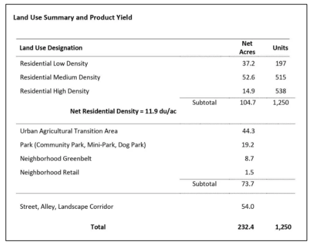
The Willowgrove proposal includes a total of 1,250 residential units across multiple density types. Project documents show a range of housing forms from detached single-family homes to townhomes and multi-story apartment buildings. Approximately 197 units are designated low-density residential, with medium- and high-density housing making up the majority of the site.
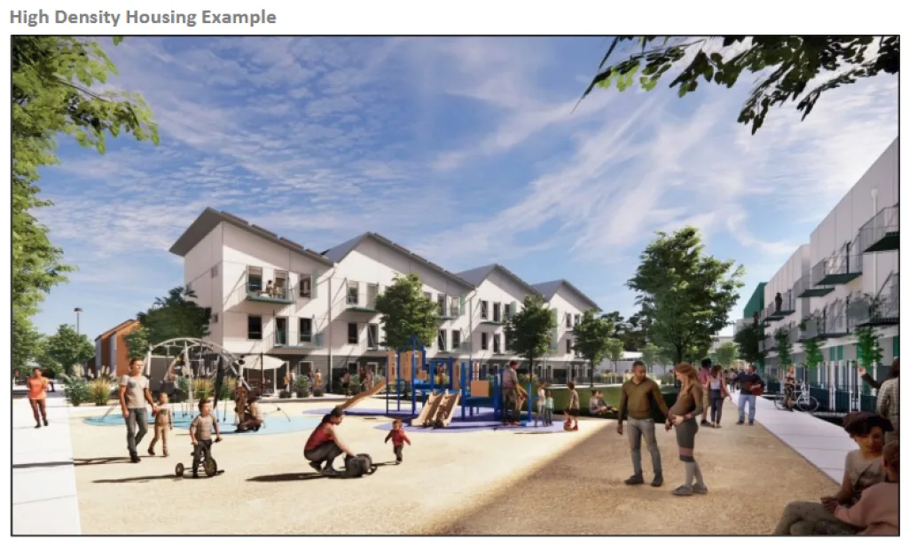
Affordable housing comprises a significant portion of the high-density area located near East Covell Boulevard. The filed project description states that 250 affordable units will be constructed in partnership with Mutual Housing California, representing 20 percent of total homes and exceeding the city’s current affordability requirement.
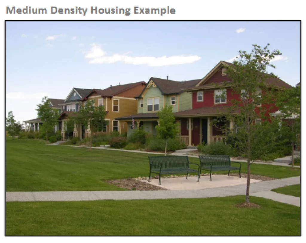
The project includes an additional category referred to as “attainable by design” housing intended for what planners describe as the missing-middle segment. These units are not deed-restricted but aim to provide lower purchase prices than traditional detached homes by using smaller land footprints and attached building designs.
Beyond housing, the tentative map identifies a proposed 18.5-acre community park featuring ballfields, an inclusive playground, a gymnasium building and open space aimed at both residents and existing nearby neighborhoods. Smaller open-space amenities include a mini-park, dog park, trail nodes and a neighborhood greenbelt system.
The project description identifies 72.2 acres of “green infrastructure,” including agricultural buffers, parks and internal greenbelts. Interior trail routes connect to the Wildhorse agricultural buffer and to a planned extension linking the site with the Gill Orchard trail to the north. An existing grade-separated crossing under East Covell Boulevard forms the primary bicycle and pedestrian access point toward schools, retail stores and the broader Davis bike network.
Project materials describe an emphasis on internal circulation intended to reduce reliance on driving. A transit stop is integrated near the southern edge of the site adjacent to the high-density housing, which project designers state is intended to place higher-occupancy residential buildings near multimodal services.
The Draft EIR release begins a mandatory public review period prior to future public hearings at the Planning Commission and City Council. Under Davis law, annexation projects must not only receive land use and environmental approvals, but also must be approved by voters before proceeding. The tentative map filings provide one of the most detailed early looks at any project expected to face a ballot under Measure J/R/D.
The full circulation package includes the Draft EIR, the Project Description dated September 2025, and the vesting tentative subdivision maps submitted July 2, 2025. Those documents remain available for public review throughout the comment period.
Once the circulation window closes, consultants and city staff will prepare responses to submitted comments. Any required revisions will be incorporated into a Final EIR before the project proceeds to public hearings and eventual voter consideration.
City staff will announce the exact closing date for the comment period and future hearing dates once the circulation notice has been posted with required legal publication.
Follow the Vanguard on Social Media – X, Instagram and Facebook. Subscribe the Vanguard News letters. To make a tax-deductible donation, please visit davisvanguard.org/donate or give directly through ActBlue. Your support will ensure that the vital work of the Vanguard continues.

If approved will all the new housing on Covell create a traffic “crisis” on the Mace curb? (-:
No
David, what makes you say that? There already are traffic backups on southbound Mace all the way from the I-80 on-ramp past Alhambra and onto the Mace Curve. How will adding all the Willowgrove traffic not make that backup worse?
It’s an important question to ask. In my view, and I hope in coming weeks to amplify it with some reporting, the traffic is not coming from the local neighborhoods. I’ll give two brief examples here. Last week I drove to Woodland Court at 8 in the morning on Pole Line/ 102, and what I saw was instructive – a steady line of traffic going southbound from Woodland. What I did not see was a steady stream of traffic coming from Wildhorse. Last year, I remember dropping my daughter off at the high school for soccer, and I drove back via Covell, I followed the traffic there and they weren’t going to the neighborhoods either, they mainly headed for i-80, having had conversations with some of the traffic analysts, that’s a normal occurrence. And so like Richard, I believe if designed properly, we could actually reduce traffic because we can take some of those commuters and give them housing locally. The traffic analysis for this project shows a reduction of VMT on a regional level as the result of these two proposed projects.
Based on my 2022 conversations with CalTrans, the lions share of that traffic isn’t coming from a Davis origin. It is cut through traffic. So giving those cut through drivers the option of a Davis residence will not change either their Vacaville work address (as one example of many possible work addresses west of Davis) or their Sacramento residence address (as one example of many possible work addresses east of Davis).
The traffic history and patterns on Mace south of I-80 validates that CalTrans opinion. The vast majority of the backed up traffic on Mace between HM Claus and I-80 is cut through traffic.
No. If designed properly to attract some of the 17,000 people who now commute into Davis, the traffic load should decrease because they will be much more likely to use means other than cars to commute to work.
Yeah right, so adding 3000 new residential units to Covell Blvd will actually decrease traffic in Davis and on the Mace curb? Tell me, who’s really buying that?
“ The vesting tentative map filed earlier this year marks a first for Davis: no previous annexation project has completed both small and large-lot tentative maps before securing City Council approval or voter authorization under Measure J/R/D.”
This comment is an illuminates one of the major reasons that past Measures J projects were rejected at the ballot box. Measure J was put forth by the citizens of Davis because the City staff, City Council, and Mace Ranch developer had proven by their actions that they could not be trusted to abide by the buildout terms of the development project agreements. It proposed to accomplish that accountability in conjunction with better thought out and more thoroughly thought out planning. Unfortunately, in its wisdom the City Council and City staff decided in each Measure J project that having a tentative map wasn’t necessary for thoroughly thought out planning. As a result many voters voted no at the ballot box because they felt the project plan was incomplete and not ready for prime time.
Hopefully this step taken by Willow Grove is the norm going forward. It also should be the standard that Village Farms should achieve by revising its efforts.
Arguably, such a vesting tentative map should be part of the submission to the EIR consultant prior to that consultant beginning work on assembling the Draft EIR.
This proposal is in an even-worse spot than Village Farms, in regard to the very definition of sprawl.
If it wasn’t for at least a half-assed attempt at adhering to fake RHNA targets, I’d personally rather see wealthy Bay Area transplants moving to Davis, rather than those without any money (if sprawl is going to be pursued). Doesn’t the city already have fiscal challenges?
If they developed Village Farms so that it doesn’t go past The Cannery, preserved everything to the north of that, AND preserved the Shriner’s site as agricultural mitigation/farmland, that might be a proposal that could pass. (Oh, and a grade-separated crossing for Village Farms, paid for by the developer.)
As for the housing mix – who cares? The ONLY thing that conceivably has ANY relevance is if the Village Farms proposal actually addressed expected, but fake RHNA targets (by income level).
As far as David’s fantasy that these proposals (including, no doubt, another attempt at DISC) won’t have any impact on traffic, I’m not sure what world he’s living in. But given that he himself drives to work WITHIN Davis . . .
Ron O
Since you live in Woodland with no discernable relationship to Davis, we don’t care about your opinion on this or any other development. You provide no factual basis or informed analysis that might be useful from an outsider. Since you’re not a valid stakeholder, your input is unnecessary and adds nothing of value.
BTW, the Davis Citizens Planning Group’s proposal on Village Farms that you have repeatedly disparaged can fit 1800 homes below the Cannery’s northern border.
You “doxed” by your own definition the DJUSD superintendent on the Vanguard’s Facebook page, posting as Ron NA. You stated what town he lives in. You’re a hypocrite.
But the main problem regarding the only substantive comment that you (and the 4 other “Davis residents”) in your group is flawed, since it doesn’t address preserving the land north of the 1,800 unit reduced-size site that you advocate for.
Instead, it “preserves” that site for FUTURE DEVELOPMENT.
How is that a “benefit” for the city? All of the negative impacts of the current proposal, PLUS the negative impacts of a future proposal!
When you’re answering this question, be sure to do so by stating that I don’t live in Davis. Seems like a pretty convincing argument in your mind, at least.
Ron O
Your opinion about what happens to the parcel north of the Cannery doesn’t matter because you’re an outsider not connected in any way to Davis. We propose that the decision as to what to do with that area be left to the citizens of Davis, not to you as an outside interlocutor. We are agnostic on the question of preservation for what purpose.
That said, we’ve obviously presented an option that leaves that question open. But you’re repeated critiques of what we proposed have NEVER said anything about the question of what to do with the northern part of the parcel. That’s truly a trivial criticism given that we have never said that we are addressing every issue related to Village Farms. We’ve always been giving options and preservation of that land easily fits as one of the options.
I state that you don’t live in Davis so that others reading this understand that you are simply an unproductive “Malthusian troll” with no valid standing in the discussion.
What about being a hypocrite on “doxing”?
Richard: Aren’t you the same individual who advocates for elimination of Measure J, in order to disenfranchise your fellow Davis residents?
One of my comments is not being posted, but I’ll go ahead and answer your latest question. You referenced an article which included a brief reference to me (several years ago), and which didn’t even state anything about where I lived. The article was not about “me” in any sense of the word, and was totally unrelated to any “campaign”.
In contrast, Matt Best went “out of his way” in an article devoted entirely to himself, to “prove” that he couldn’t live in Davis as a principal at DJUSD. This is part of what can only be called a “sprawl for schools” campaign, by the now superintendent of DJUSD.
So again, I’ll ask – why didn’t Matt Best seek employment in the city where he actually lived? Isn’t this YOUR type of concern – living and working within the same city – to avoid the impacts of commuting?
“Malthusian troll”
Thank you Richard. Emulation is the finest form of flattery.
Richard, if you care to do just a little bit of research/homework, you will be able to disabuse yourself of you delusion that Ron has “no discernable relationship to Davis.” Your recurring statements about Ron are fake news.
Ron Glick, well said. Very well said.
“Since you live in Woodland with no discernable relationship to Davis, we don’t care about your opinion on this or any other development.”
Who’s we? I care.
Speaking for myself I don’t care what Ron O. thinks or where he lives. The only thing that bothers me is the gluttonous volume of nonsense he produces. Fortunately I skip most of what he writes. I do however appreciate Richard pointing out that he doesn’t live in Davis for those unfamiliar with his Malthusian trolling.
Richard, if you care to do just a little bit of research/homework, you will be able to disabuse yourself of you delusion that Ron has “no discernable relationship to Davis.” Your recurring statements about Ron are fake news.
I am heartened to see this language: “The project includes an additional category referred to as “attainable by design” housing intended for what planners describe as the missing-middle segment. These units are not deed-restricted but aim to provide lower purchase prices than traditional detached homes by using smaller land footprints and attached building designs,” which to me sounds like duplexes and townhouses. But looking at the plot plan, even the Medium Density area is broken into separate lots, and not all that small (3,200 sf seems to be the smallest), so doesn’t look like any attached houses in those areas. There is another area called “condominiums,” and I thought perhaps that’s the attached housing, but the traffic study in the EIR (page 4.13-21) lists 712 detached houses, 233 units Affordable Housing (obviously apartments), and 288 “Multi-family housing low-rise.” Those sound like apartments too, and technically are “attached,” of course, but seems misleading to use that word. David, can you point to where the “attached building designs” language came from?
“But looking at the plot plan, even the Medium Density area is broken into separate lots, and not all that small (3,200 sf seems to be the smallest), so doesn’t look like any attached houses in those areas.”
I used to live in one of the split-lot duplexes on East 8th Street near the cemetery. Most of those attached-dwelling lots were around 3,700 s.f., with a few smaller and a fair number larger.
It’s amazing to me. People spend millions of dollars coming up with a comprehensive plan for something that should pass muster with the voters of Davis and you guys immediately start picking it apart.